Skip to content

Month: November 2020

Worldbuilding 101 – How to Map Your Fictional World – Climate

So far in our worldbuilding series on creating fictional worlds, we have figured out what map projections to use and created some basic continents. In this article, we are going to put them together to see how latitudes and placement of continents affect how climate manifests on the world we are building.

Basic Climate Model

Before we start worldbuilding the climate, we need a basic climate model. Climate zones are driven by atmospheric circulation. The sun heats the surface of the earth unevenly. This will be true of any globe. The sun is overhead at noon at the equator, at least at the spring and autumn equinoxes.

With the sun overhead, the surface of the planet gets heated at the equator more than it does at higher latitudes. This causes warm air to rise at the equator, pulling in cooler air at the surface. The air tends to sink at about 30° latitude, falling back to the surface. this creates a cycle of air being lifted at the equator and pulled from 30° latitude back to the equator. This is called a Hadley Cell after the scientist who first described it.

Additionally, the air at the poles is cold, so it sinks, creating another cell of circulating air between 60° and 90° latitude. This is the Polar Cell, named for obvious reasons.

The final cell is the Ferrell Cell, driving air circulation at mid-latitudes between 30° and 60° latitude. This is a weak cell, so the air circulation in these temperate latitudes is less uniform.

These cells create low and high pressure zones at the latitudes where air rises and falls. Rising air creates low pressure as the air mass is stretched. Sinking air creates high pressure as the air mass is pressed down by sinking air.

Image: Kaidor, CC BY-SA 3.0 <https://creativecommons.org/licenses/by-sa/3.0>, via Wikimedia Commons

High and Low Pressure Zones

As a result of these atmospheric cells, we get zones of high pressure at about 30° latitude and at the poles, and low pressure at the equator and 60° latitude.

Climate zones in the basic model. Image by Michael Tedin

High pressure zones are associated with low humidity and clear, sunny skies. Low pressure zones are associated with clouds and precipitation. This means we get arid zones at about 30° and the poles. We also get wet weather at 60° and the equator. The area at the equator is called the Intertropical Convergence Zone (ITC).

If your world has seasons, these zones will move north and south throughout the year. The poles of the earth are not perpendicular to the plane of the solar system your planet lies in. This means the sun is overhead at noon in the northern hemisphere at 23.5° N (The Tropic of Cancer) at the spring equinox. The area between 23.5° N and 23.5° S are called the tropics. For your world, you can vary this somewhat, but too great a variation will cause either wild seasonal swings or no seasons at all.

Another factor is climate change. As the planet cools or warms over geological time, the polar zones will move to lower latitudes, expanding ice caps. The high pressure zones at 30° become drier in warm cycles and moister in cool cycles. You can explore this phenomenon when designing your own world.

Prevailing Winds

Based on our discussion of cells of air circulation earlier, we can see how they would create winds at the surface that are fairly uniform. However, the planet’s rotation will defect the prevailing winds toward the west. This is called the Coriolis Effect.

Prevailing winds in the basic climate model. Image: Michael Tedin

The Coriolis Effect also tends to cause the winds to rotate, causing cyclones in the low pressure zones. These cyclones are areas of even lower pressure than the surrounding area. Winds rotate around them as the cyclone moves across the latitude. More on that later.

Where trade winds converge in the ITC, there is the phenomenon known as the doldrums, or areas of little wind. Tropical cyclones usually form around the autumnal equinox when the doldrums are farthest from the equator.

Applying Continents to the Map

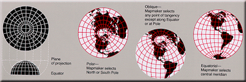
At last, we get to see what our continent looks like on a map. I only plan to use a portion of the continent as a setting for my fictional world, but I want the continent to span a wide variety of latitudes. It will stretch from the sub-polar to the equator. This means I need to use more than one map projection. I will use three different projections and stitch them together.

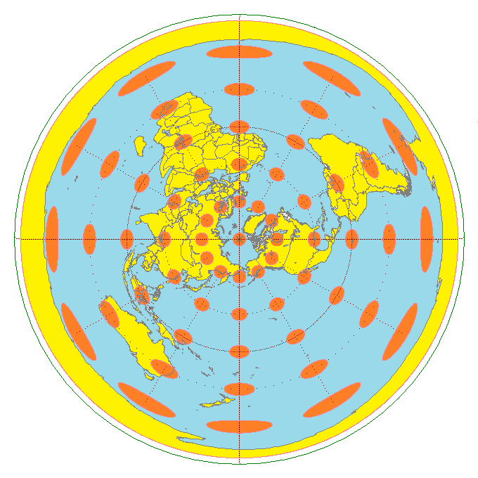
At the equator I’ll use an Equirectangular Projection. This has minimal distortion between 10°N and 10°S. In the mid-latitudes, I will use an Equidistant Conic Projection. Distortion is least between 20° and 60°. The least distortion is around 40°. At the poles, I’ll use an Azimuthal Equidistant Projection centered at the pole.

Stitching them together is a bit of a cheat, but we end up with an area like so:

Multiple map projections stitched together. Image: Michael Tedin

Needless to say, this map still has some areas of distortion, but I have tried to minimize it.

Distorted areas outlined in red. Image: Michael Tedin

Adding the climate zones from our basic model above:

Basic Climate Model on a flat map projection. Image: Michael Tedin

Next, we add the continent. I added a volcanic island in the middle of the spreading ocean similar to Iceland. I can imagine all sorts of story ideas to go along with this island. We’ll start to see the possibilities as we progress.

Continents superimposed on the Basic Climate Model. Image: Michael Tedin

Now we have a world with bands of desert, grasslands, and forest on a pair of continents with plains, hills, and mountains. But we aren’t finished.

Effect of Continents on Climate Zones

Once we have the continents placed they also affect climate. Because the oceans trap heat more than solid land, large land masses create high pressure zones and large water masses create low pressure zones. This expands the high pressure zone over continents around 30° and expands low pressure zones over oceans at 60° and the equator. There is also the phenomenon of Thermal Lows that affect climate, bringing monsoon rains onto the continent.

Cyclones

The tropical cyclones I mentioned earlier bring moisture from the ITC to higher latitudes. These are hurricanes and typhoons. They generally form over tropical seas at about 10° latitude around the autumnal equinox. High heat and humidity around the doldrums cause thunderstorms that spin due to Coriolis force. These thunderstorms merge into a larger cell.

Such tropical storms move from east to west across the ocean, picking up energy over warm seas. In the northern hemisphere, Coriolis effect causes them to turn right, moving north at about 20° N. The effect is the opposite in the southern hemisphere. These storms bring high levels of moisture to the eastern margin of continents.

On our new world, cyclones might form to the east of the continent beyond the map or in the mouth of the spreading sea. They will move westward across the warm sea, gaining strength and moisture. They will eventually moving north around the central island and bring moisture to the southern edge of the continent in late summer where there would otherwise be a desert. That central volcanic island now has tropical jungles. I think a good name for the eastern part of the sea would be Sea of Typhoons. It’s starting to look like the setting for King Kong.

Also, certain local conditions will affect climate. Mountains trap moisture and are cooler at high altitudes. This will create forests at the northwest of the continent where mountains have formed. These mountains are high enough and close enough to the poles to create glaciers.

Hills and mountains also disrupt prevailing winds. Disturbed air in these regions increase precipitation. Large inland lakes will also moderate climate, increasing moisture and cooling adjacent deserts or warming adjacent polar areas. We don’t have any large inland lakes yet. That’s a topic for my next article.

The Final Map…So Far

The final map after worldbuilding climate. Image: Michael Tedin

Now our worldbuilding has created climates. I added some more detail based on the Köppen climate classification. Köppen’s system is complex enough to cover a wide variety of climates. You don’t need to get as detailed as this. You could simply identify forest, plains, and deserts. The advantage to using this system is that you have a reference to know just how those areas play out at different latitudes and locations.

This Is a Lot of Work. Do I Need to Do All This?

My worldbuilding process gives you a map with a lot of different environments. If you want a desert setting, you have one to the west. If you want a tropical setting, you have one to the south. The eastern part of the northern continent is similar to eastern North America, which is in turn similar to Europe. There is a wide variety of environments to choose from. At the same time, it is limited by certain parameters I set in my head.

This does not mean you are limited by those parameters when worldbuilding. Think about what happens if you tweak any of those parameters. If you diverge from any of the rules I have laid out so far, you can set a story in a world where the rules don’t work as expected. This is the essence of fantasy. For example, in N.K. Jemisin‘s Broken Earth trilogy, the geology of the world is altered by magic. Once you understand how these processes work, it is easier to build a world that still works even if you break the rules.

Why Follow This Process?

Why is it important to know how continents move, how climate works, and what kind of plants and animals live in certain areas? Because as much as culture is determined by ideas, culture is also determined by environment.

It seems like an obvious thing to say, but our environment affects how we think about the world. Keep this in mind when going through the worldbuilding process. Remember that the goal of worldbuilding isn’t just to have a world, but to develop stories, whether they be novels, movies, or games. We are creating a setting, but characters live in the setting and are affected by their environment and culture. Many of their choices might be determined by those factors.

The advantage of having a complete and robust world is that you will already have an idea of how your characters will react to the world around them without having to think it up on the fly. You can move them from place to place and know whether the new setting is something they recognize or is completely foreign to them.

Up Next

We have one more topic to cover before populating the world and creating cultures. In my next article, I will talk about biomes (flora and fauna), mineral resources, and landforms created by climate.

Comments closed

Worldbuilding 101 – How to Map Your Fictional World – Continents & Plate Tectonics

In this article, I am going to discuss plate tectonics and how to use it in your worldbuilding to create an interesting fictional map. If you are creating a fantasy setting for your story or game, you want to make the world interesting, but also have it make sense geologically.

I have seen so many fantasy novels with a map at the front that make absolutely no sense from a geological view. How did that mountain range get there? Why is there a lone volcano in the middle of a continent? Tolkien is not immune from this critique, but I’ll give him some slack because he created his world before the theory of plate tectonics was developed.

Why a Continent Sized Fictional Map?

We previously discussed how maps are less distorted when looking at smaller areas of a globe, so we will work with a continent or two at a time. We are going to build continents from scratch by exploring plate tectonics.

Based on my last worldbuilding maps article, we understand how curved surfaces are distorted when laid out on a flat map. Armed with that knowledge, we can start putting ideas on the map. I don’t recommend doing what I did and plaster paper on a globe and move the continents around. We’re going to switch back to working with a flat map.

Plate Tectonics

The basic concept of plate tectonics is that plates cover the planet, moving across the surface of the globe. The plates may be continents, ocean floor, or a combination of the two.

The basic concept is that spreading zones push the plates across the globe and where they meet on the other side, there is a subduction zone. There are also transform sliding boundaries, but we will skip that for now.

Schematic cross-section of plate tectonics from Simkin et al. (2006) This dynamic planet: world map of volcanoes, earthquakes, impact craters, and plate tectonics: U.S. Geological Survey Investigations Series Map I-2800, 1 sheet, http://www.minerals.si.edu/tdpmap/index.htmImage prepared by Jose F Vigil and Robert I. Tilling.

Cratons

Each continent has a core, called a craton, that moves across the surface. The craton is moved across by the force of the spreading zone. Here’s an example. Let’s call it Circlea, because, well.

Image by Michael Tedin

The leading edge of the craton is pushed up and distorted as it moves across the surface. The interior and following edge stay relatively stable, geologically. We will see some exceptions to this later. We will also see how landforms are created in these areas in later articles. For now, let’s focus on the leading edge.

Leading Edge of Continents is Geologically Interesting

As we saw in the first image showing the cross section of the plates, subduction zones create volcanoes. Anyone in the Pacific Northwest, Central America, or the Andes is familiar with these.

Image by Michael Tedin

These volcanoes raise high mountains and extend the land of our fictional map of Circlea, often in arcs extending away from the craton. This is often the most basic of continents. South America or Antarctica are examples of this.

Island Arcs

Sometimes, the subduction zone might jump, creating a chain of islands off the coast of the continent. These islands become the volcanic mountains of the subduction zone while the former mountain range of the continent erodes into hills or low mountains. This might also be a good time to talk about back arc spreading, but let’s not get too complicated. You can research that for homework!

Image by Michael Tedin

Now we’re starting to get some interesting landforms to set a story or game in. You could focus on the lands along the sea behind the island arc. Set the villain in a volcanic region and the peaceful villagers in the hills on the continent. With some horse-riding marauding bandits from the interior or pirates on the coast, you’ve got a good setting already.

Examples of the island arc would be Japan, Solomon Islands, Phillippines, Indonesia, pretty much the whole western Pacific. But why stop here? Let’s see where we can take this.

Image: Geophysical Atlas of the Sea of Okhotsk
Compiled and edited by Øyvind Engen, Sverre Planke, Reidun Myklebust, Frode Sandnes, and Erling Frantzen. https://vbpr.no/products/geophysical-atlases/geophysical-atlas-of-the-sea-of-okhotsk/

Gathering Terranes

Over time, as more seafloor is subducted under Circlea, the leading edge scrapes up bits from the bottom of the ocean. These may be the new island arcs, seamounts, other islands, underwater landslides off the continent, or simply the muck that lies on the bottom of the sea. All this gets accreted onto the continent. It’s still pretty circular.

Image by Michael Tedin

This fictional map is starting to look more like North America. Again, we’ll ignore back arc spreading and transform sliding boundaries. It might be more interesting geologically, but for a story setting, less interesting than the island arcs.

Image: Maps of the World

Colliding Continents

Want to see something really interesting? What happens when two continents run into one another? When the continent uses up all the seafloor, it will eventually run into another continent. Circlea, meet Ringel. That’s when things get really mixed up. It creates interesting geology as well as an interesting story setting.

Similar to what we saw with island arcs and gathering terranes above, we start seeing islands popping up between the continents. These might be volcanic seamounts shoved up from the bottom of the ocean or simply bits of ocean floor that have no place else to go. As with one continent, the mechanisms are the same, but the complexity rises. Both continents are scraping the oceans as well as affecting each other. Land has nowhere to go but up.

Image by Michael Tedin

So Much Story Potential

Like our discussion of story possibilities previously, this has a lot of potential as well, but the complexity increases by a factor of two. Now there are multiple islands in the inland sea. Pirates could be on any of them. There are two possible directions the marauding horsemen could be coming from. Where is the villain? In the volcanic mountains? On an island in the sea? Leading the horsemen? The peaceful villages are literally squeezed between two continents.

What real-world analogy of this can we find? The Mediterranean Sea between Eurasia and Africa. All these story possibilities have analogies to European and Middle Eastern History.

File:Tectonic map Mediterranean EN.svg
Woudloper, CC BY-SA 1.0 https://creativecommons.org/licenses/by-sa/1.0, via Wikimedia Commons. File

Pancirclea

Eventually, the two continents will fuse into one. The sea is gone in our new fictional map. In its place, the mountains and islands have created a high mountain range separating the two continents. Now we have Pancirclea.

Image by Michael Tedin

This has happened with all the continents in Earth’s geological history, creating the mega-continent of Pangaea.

File:Pangaea 200Ma.jpg
Image: Fama Clamosa, CC BY-SA 4.0 https://creativecommons.org/licenses/by-sa/4.0, via Wikimedia Commons. File

Hidden Mountain Kingdoms á la Shangri-La

While you might have lost the potential for great stories about pirates and sailing, you now have the potential for stories of hidden mountain kingdoms sealed off from the rest of the world by snow and glaciers. Perhaps those kingdoms have dug warrens of tunnels and caves through the mountains that are now overrun by goblins á la the Mines of Moria from Tolkien.

For a modern world example, the Himalayas are exactly this kind of high mountain range. The continents of Asia and subcontinent of India collided to raise the Himalayas to be the highest region on Earth.

File:Himalayas landsat 7.png
Photograph: NASA, Public domain, via Wikimedia Commons

Breaking Up is Hard to Do

You might think we’ve covered all there is to cover in creating interesting settings based on plate tectonics, but we haven’t. What happens when Pancirclea starts growing apart? It’s time for the big split.

Even Pangaea broke up into multiple continents, resulting in the world we see today. The reasons for the breakup aren’t clear, but scientists believe that it is caused because the continents are pulled apart by its own weight. Others have posited that they are pushed apart when a continent moves over a hot spot which forces magma up and out.

In any case, we can mimic a continental breakup. I simply drew a wavy line through the middle of my continent. As the continent breaks up, it doesn’t do so evenly, leaving failed rifts. These often later become filled by erosion, though in some cases, might also create smaller, mini continents that break off the larger continent.

Image by Michael Tedin

The rift zone might not create a full sea, though over time it might. It might simply create a series of lake-filled valleys like the East Africa Rift Zone. This extends to the Red Sea, where a new ocean might be in the process of growing.

File:East Africa Rift System GPS and stresses.png
Mikenorton, CC BY-SA 4.0 https://creativecommons.org/licenses/by-sa/4.0, via Wikimedia Commons. File

New Continents: The Cycle Starts Again

Along the margins of the new inland sea you might find shield volcanoes. These are the flat, low volcanoes like Mauna Loa in Hawaii. they are very different from the explosive volcanoes like Mt. St. Helens in the Pacific Northwest.

As the continents move apart, the inland sea grows. I like inland seas. They offer up so many opportunities for writing about sailing and pirates. Who doesn’t like a good pirate story?

The volcanoes along the edges of the rift die down as the spreading zone stays at the center of the new ocean. The high mountains have eroded into low mountain ranges and hills. Pieces of the old continents are pulled apart, some subsiding and falling into the new ocean. Others break off and create new mini-continents.

The leading edges of the new continents now go through the same process that we started with at the beginning of the article. The new leading edge is pushed up and distorted, while the old leading edge is now the trailing edge, relatively stable geologically.

This new fictional map is a far cry from the simple circle we started with.

Image by Michael Tedin

This is exactly how the Atlantic was formed between Europe and Africa on one side and the Americas on the other.

File:Central atlantic.png
Zkelly1, CC BY-SA 3.0 https://creativecommons.org/licenses/by-sa/3.0, via Wikimedia Commons. File

What Kind of Fictional Map Have We Ended Up With?

Eventually, these two continents will be too far apart to have much influence on each other in a story unless your world has ocean-going technology or flight. Once you get to that point, you are getting out of the realm of low fantasy. Perhaps your world has magic advanced enough for those technologies, then you are into high fantasy. It might also allow a good science fiction or steampunk story world.

By now, we have created a fictional map of a wide variety of continents, from simple Circlea to its growth and meeting of Ringel and the beautiful inland sea they created together. Then they merged into Pancirclea and later broke apart.

If you don’t want to go through the whole process of creating continents from scratch, you don’t have to. You can simply draw one out, but you should understand the mechanisms of continental development if you want a setting that makes sense geologically.

Another option is to let someone else do it for you. I found a fun tool that models plate tectonics at Tectonics.js. It creates continents, runs them through time and motion. It works on a globe, but also maps them on a flat surface. It’s pretty slick. A lot of math went into the model, I’m sure.

What’s Next?

We did not discuss what these different continent types might look like at different latitudes or how they get mapped. We also didn’t discuss the effects of erosion, except in passing. That will be the topic of my next article about climate and its effect on the world. Also coming up, what are we going to do about that evenly curved trailing edge of the continent? How boring is that?

2 Comments

Tips for Cooking Thanksgiving Dinner

Given the current COVID restrictions and the recommendation to limit the size of holiday get-togethers this year, many people will likely be cooking smaller Thanksgiving dinners. If you don’t feel comfortable joining the extended family for fear of infecting grandma (or Cousin Eddie infecting you), you will probably want to keep your holiday dinner small.

Please keep your gathering small. Large gatherings are probably the main cause of the explosion in coronavirus cases this fall. The CDC is recommending gathering only with people in your own household. This means you will have to cook your own dinner.

I’m here to tell you that you can do it. The trick to putting together a fantastic feast is proper planning and preparation. Start early. Start now. The weekend before the holiday is when most people go shopping for ingredients. You can start preparing dishes days ahead of time, though I usually start that the night before.

Set the Menu

Step one is to put together a meal plan. What are you going to serve? You won’t have Aunt Mabel’s pumpkin pie, but maybe she’d be willing to give you the recipe. Cousin Eddie likes the green jello salad with pineapple and cheese, but do you? If you don’t like yams or cranberry sauce, skip them.

Woman Sitting on Table Holding Black Whisk and Cookbook
Image by Georgia Maciel

In the past, I have usually gone to someone else’s Thanksgiving dinner and then cooked another one for me and my wife a couple days later. That way, we can have leftover Thanksgiving for days. I have a set list of traditional dishes that I like to cook.

Think Smaller

Unless you like having a lot of leftovers like I do or have limited refrigerator or freezer space, you want to set your menu more modestly than you would if you were having the whole extended family over. You have to have a lot of dishes and plenty of them when you have to feed everybody including second cousins and whose kids are those? This year I plan to drop a couple and replace them with one that sort of combines them.

The centerpiece is always the turkey, but do you need a whole one? You could also do something smaller like chicken or duck if you want to have something special. You could also do a beef or pork roast. If you are doing turkey, you could just roast a hindquarter or breast. I don’t recommend the breast for a centerpiece unless you find a recipe that compensates for the dryness of it.

https://www.artfrommytable.com/3-secrets-to-perfect-roast-turkey/

For sides, feel free to have fewer. I like sweet potatoes and squash, stuffing and mashed potatoes, cranberry sauce and brussels sprouts. But that’s a lot of food for two people or even four. Even just having three of those is a lot of sides. But it’s supposed to be a feast and there’s room in the fridge for leftovers, right?

It’s a good idea to choose sides that all cook at the same temperature. If you don’t, you will have to cook one dish while another is getting cold. See Plan the Timeline below. This year, I plan on combining the brussels sprout and sweet potatoes into one dish. Be creative. The internet is full of ideas.

Go Shopping

Once you have a menu, put together your shopping list. I recommend going shopping early. You don’t want to get to the store and find that all the turkeys have been sold. There have been rolling shortages of various items throughout the year, from toilet paper to canned tomatoes. There will probably be more shortages this year because 2020.

Grocery Cart With Item
Image by Oleg Magni

If you have a well-stocked pantry, you probably only need a few things, like a turkey. Most people don’t keep an extra turkey on hand. ahem…

If you are a casual cook, chances are you’ll need to buy most of what you will need. One thing I always have on hand, but always seem to need more of come Thanksgiving is butter. Lots and lots of butter.

Also, if you are a casual cook, there might be a few kitchen implements you will need to do the dinner right. For example, I highly recommend getting a meat thermometer. I like the electronic kind. You can get some relatively cheap ones. Do not rely on the little popup thingy that comes with the turkey. Those things are no more than crappy plastic darts. Also don’t rely on the recipe’s cook time. Turkeys vary in size and temperature, so their cook times will as well. If you want to know whether your bird is done, use a thermometer.

See the source image
Copyright

Other things you might need are roaster pans for the turkey or other pans or dishes for all the sides you have planned. You might need more serving spoons as well. Take stock of your kitchen and figure out what will be needed for each dish.

Plan the Timeline

This is probably the one thing that new cooks don’t think about. I never did. The trick to getting multiple dishes ready and on the table at the same time is to set a schedule. Set a goal for when you want dinner on the table. Figure out the time each dish takes to cook and work backward. Add about a half hour to an hour to the timeline because things always take longer than expected. It’s better to eat early than have people waiting, eyeing your kitchen hungrily.

Pen on to Do List Paper
Image by Breakingpic

You’re going to have a bird in the oven at anywhere from 325° to 500° and probably changing at some point during the cooking process. The sweet potatoes need to cook at 350° and the pie at 400°. Plan for times that each dish needs to be in the oven.

You can be preparing the side dishes while the turkey is cooking. If you have a large turkey, you have more time to prep, usually a couple of hours at least. If you are doing a smaller bird such as a chicken, duck, or turkey thigh, you might just have an hour.

One advantage you have is that the turkey needs to rest for 30 minutes once it comes out of the oven (less for a smaller bird). That is the perfect time to finish off those side dishes you have already prepared.

Start preparing early.

That’s right, you don’t have to cook everything on Thanksgiving day. I usually cook the pumpkin pie (or other pie you like to have) the day before. You can also make the cranberry sauce early. It needs to refrigerated anyway. If you are making rolls from scratch, good luck, but now would be the time to start them.

Thaw the bird!

If you don’t, you can still cook it, but it will take longer and you’ll have to take it out of the oven after an hour or so while it’s hot so you can extract the giblets bag that was frozen to the inside of the cavity. This is another good reason to go shopping early. As soon as you get it, put the turkey in the refrigerator or a cooler on ice. If you want to brine it, that will need to start early as well, usually the day before.

Other turkey recipes require preparation that can happen the night before. If you like to have dinner early, I recommend doing as much as you can the night before. Otherwise you will be up at o-dark-thirty to start the prep. I like to have dinner at about 5pm, so it’s not necessary to get up too early.

You can prep other dishes or even just parts of dishes. I usually prep the stuffing aromatics the day before and add the bread to it the next day just before I cook the final dish. Putting it all together early makes the bread soggy, but the onions and celery can be cooked the previous day to await the bread on Thanksgiving itself.

Thanksgiving Day

Image by Rodnae Productions

If you have figured out your schedule, you probably know when things need to go in the oven. The turkey usually goes in first. The longer cook time lets you prep other dishes.

If you have planned and prepared, this should go like clockwork. Keep your timeline and recipes handy so you know what step you are on and what needs to happen next.

While the turkey cooks, you will be preparing the side dishes, putting them in their cooking vessel, and getting the serving dish ready. If you serve them in the same dish they are cooked in, that makes it a lot easier, but be sure you have enough trivets to put them all on the table. They will be hot.

When the turkey is done (about 165° in the breast), take it out of the oven and cover with foil to rest while you finish the sides. The sides should all be prepped and ready to pop in the oven. Set the temperature as needed. If the final temperature for the bird is the same as needed for the sides, all the better.

Dig in!

If you have everything properly planned and prepped, you should be able to sit down with your family to enjoy a wonderful dinner. No last minute oops I forgot this or working in the kitchen while everyone else is eating.

Norman Rockwell: Freedom from Want (pre-coronavirus)

My Thanksgiving Plan

I will share my normal Thanksgiving plan here. It is actually my plan for 2nd Thanksgiving, you know, the one for the Sunday after. I just can’t get enough turkey!

Gravy base – Saturday
Flour, butter
giblets, celery, onion, sage (for turkey stock to add on Sunday)

Stuffing – Prep Saturday, assemble & cook Sunday 1-1/2 hr
Bread cubes, chicken stock, sausage, Celery, Onion, mushrooms, thyme, butter
http://food52.com/recipes/1452-what-we-call-stuffing-challah-mushroom-and-celery

Cranberry Sauce – Saturday
Apple Cider, Sugar, Pectin, Cranberries
http://food52.com/blog/9084-homemade-cranberry-sauce-in-a-can

Pumpkin Pie – Saturday
Grandma Haniszewski’s Recipe (this is probably from the back of the Libby’s pumpkin puree can in the 50’s)
Eggs, flour, butter, evaporated milk, pumpkin, sugar, cinnamon

Whipped Cream – Saturday
Cream, sugar
http://food52.com/blog/8956-how-to-make-whipped-cream-ahead-yes-you-can

Glazed Sweet Potatoes – Glaze Saturday, assemble & cook Sunday 1 hr
Brown Sugar, Sweet Potatoes, Butter
http://www.foodnetwork.com/recipes/patrick-and-gina-neely/glazed-sweet-potatoes-recipe.html

Turkey – Sunday
Thaw 8-10 hrs (Sat Morning), brine 8-12 hrs (overnight), cook 3-4 hrs
Onion, butter, celery, sage, salt, spray oil, kitchen gloves, vegetable broth (128 oz)
http://www.bonappetit.com/test-kitchen/cooking-tips/article/alton-brown-s-perfect-roast-turkey?mbid=social_facebook

Garlic Mashed Potatoes – Sunday 1 hr
Potatoes, Garlic, Butter, cream
http://food52.com/recipes/2947-mr-l-s-mashed-potatoes

Schedule:
Turkey Noon
Giblet stock – 1pm
Stuffing – 2:30pm
Sweet Potatoes – 3pm
Mashed Potatoes – 3pm
Gravy – 3:30 pm

Comments closed

Worldbuilding 101 – How to Draw Maps for Your Fictional World

It may come as a surprise to anyone who has read The Statue of the Mad Caliph that I don’t have a map in the book. Many readers of fantasy want to have a map to orient themselves with where in the world the characters are.

I decided early on not to put a map in the book because I didn’t want to give away the history of the world and how it got to be. Rather, I wanted people to focus on what was happening in the story. By putting enough description of the physical world, I hoped readers could figure out where they were in the world.

Maybe it was the right decision, maybe not. I know some readers that don’t normally read fantasy were confused and asked for a map. The problem with a map is that it tells as much about the world as the story itself does. This raises the issue of how much to put on the map.

How I Created My World Map

Some writers don’t need to have a map for their story or are OK with just using one drawn quickly and for the purpose of the story at hand. I’m not like that. I like doing things from scratch. I make my own noodles for lasagne or chicken soup. I grow my own pumpkin for pumpkin soup or pumpkin bread.

I drew the map of my world long before I thought of using it as a setting for a novel. Let’s call the world Yerpik, because I did. The name is actually a portmanteau of Yupik and Earth. The reason will become obvious eventually.

Plate Tectonics

The world of my novel has its origins in a plate tectonics project I did shortly after graduating from college mumble-mumble years ago. I had a keen interest in geology back then and wondered what geological trends in plate tectonics would result in if fast forwarded a couple hundred thousand years or so.

I covered a globe with paper, cut it along continents, and moved the continents to where I thought they would be. It wasn’t a very scientifically rigorous experiment, but I did learn a lot, including dredging up high-school trigonometry after 4-5 years of zero math classes. For some reason, the University of Washington did not have any math requirements for social science majors.

At the time, I was much more interested in sociology, geography, history, economics, and politics than any hard STEM courses. I avoided engineers, science, and math, which is too bad. I would have been a great engineer.

Be that as it may, my college course work prepared me for world-building in detail.

World-building for Dungeons and Dragons

I played a lot of Dungeons and Dragons when I was a kid. The people I played with usually switched between being dungeon master and player. Soon, it was my turn to be DM. I needed to come up with adventures and a setting to play them in.

When we first started playing a teenagers, we would draw a dungeon, fill each room with monsters, and let the players go room to room killing the monsters and taking their stuff. This is the essence of D&D, killing monsters and taking their stuff. After a while it gets boring and players like to have a little context for the dungeon, the monsters, and the stuff. This is where story comes in.

Soon, we matured enough to put the dungeon in a region with a nearby town. Then the town had to be in a country on a continent in a world. Some of my friends liked drawing maps. Every new adventure with them was set in a new world.

One of my friends wanted to create a world from scratch, starting with a coherent geography of the world rather than something drawn quickly on an 8.5″ x 11″ piece of paper. He said he wanted to start “from brass tacks.”

Mapping a Round Surface to a Flat Map

The plate tectonics project left me with a globe covered with paper and continents that had shifted to different latitudes. That globe traveled with me from place to place for a few years before I started playing D&D again.

My friend’s “brass tacks” comment struck me and had stayed with me. I decided any world I build should be based on as much realism as possible. Looking at my globe, I chose an region to develop.

I settled on an area in the mid-latitudes that could be an analogy to a mediterranean culture. The problem I had was putting this region on a map. How do you get a curved surface mapped to a sheet of paper.

If your world is not based on a round globe, then this process isn’t much of an issue. Anything other than a round planet lies in the area of science fiction or high fantasy. If that’s the case, then ignore this whole post because anything goes.

Back to math.

Map Projections

Needless to say, a lot of thought has gone into the problem of mapping the Earth’s surface over the past couple thousand years. The problem is that, no matter how hard you try, any projection of a curved surface onto a flat map will have some distortion.

https://www.geoawesomeness.com/5-tools-will-let-master-map-projections/

The most common types of projections are cylindrical, conic, or azimuthal. Which projection should you use? Each distorts the map in some way, but some are better than others, depending on what you want to show.

For a more humorous take on different projections, check out xkcd.com.

The best approach is to take a small area of the globe and map that. The smaller the better. On the other hand, you need a map that will cover a large enough area for your story (or D&D game). I recommend an area the size of a continent. Africa or Asia might be too large, though a portion of them might work well. Try for an area about the size of North or South America or Europe.

Different projections work best for different areas on the globe.

Cylindrical Projections

The most famous cylincrical projection is the Mercator. On this type of map longitudes are parallel. So are latitudes. That means north will always be oriented the same no matter where on the map you are. But distortion is greater nearer the poles. One inch at higher latitudes covers fewer miles than one inch at lower latitudes. This means that to figure out distances and travel times, you need to calculate based on latitude.

By Stefan Kühn – Own work, CC BY-SA 3.0, https://commons.wikimedia.org/w/index.php?curid=24628

The Mercator projection is very common, but map fans hate it because of the distortion at high latitudes. On the other hand, it is great for marine navigation because any course of constant bearing can be plotted as a straight line.

Because the distortion of the map is least at low latitudes and both longitudes and latitudes are parallel to each other, this is a good projection around the equator. I’d recommend it if you are setting your world between about 20° N and 20° S.

Conic Projections

Conic projections work well at mid-latitudes. There is minimal distortion around about 30° N or S, but higher distortion at low latitudes and near the poles. The greatest distortion is past the equator, so this is a bad projection for a whole globe.

By Justin Kunimune – Own work, CC BY-SA 4.0, https://commons.wikimedia.org/w/index.php?curid=66467546

The biggest difficulty is that longitudes and latitudes are not parallel. Latitudes are shown as arcs and latitudes converge on a point somewhere off a map of mid-latitudes. This means that north will not always be in the same direction on a flat map. In smaller regional maps, this is less of a problem.

This projection is best if you are working around 10° to 50° latitude.

Azimuthal Projections

I don’t use this much because my world has little human activity at the polar regions. Yours might, though. If you create a desert world like Dune, the habitable area might be at the poles, so this projection is worth talking about.

Technically, the azimuthal projection is not limited to the polar, but in areas other than the pole, it has both the disadvantages of the cylindrical and the conic and none of the advantages.

By User:Quadell, re-coloring US Government USGS image. – derivative from USGS image file (with map sections colored red/white),URL: http://erg.usgs.gov/isb/pubs/MapProjections/graphics/azimuthal.gif, Public Domain, https://commons.wikimedia.org/w/index.php?curid=61896

At the pole, latitudes are concentric circles and longtitudes converge on the pole. Because the pole is the center of the map, it is easy to plot locations. You know where north is, and distances near the center are about equal. This projection is best at the center to about 60° above the equator.

Tissot’s indicatrix applied to the azimuthal equidistant projection
40By Kurubu – Own work, CC BY-SA 4.0, https://commons.wikimedia.org/w/index.php?curid=34460999

This projection shows the opposite pole stretched to infinity. If you want a map of the opposite pole (antipode), you can use this same projection, but from the opposite angle.

Laying out the Map

Once you have chosen the area of the globe you want mapped, lay out the latitudes and longitudes. The polar or Mercator projections are easy, but if you want a good map of a mid-latitude continent like North America or Europe, you will have to plot concentric arcs as latitudes and longitudes converging on a single point. That point will probably be far off your map. Because of the distortion, you probably won’t want to map the area around that point.

This is essentially what I did in mapping Yerpik. It made it difficult to start, but I have a map that has close to equal distances anywhere on the map. I usually only use small areas of the map, so individual maps have north at the top of the page.

I originally used MacDraw on Macintosh Powerbook to lay everything out. Everything disappeared when the computer crashed and I moved to Windows machines. I had printed out a lot, so I scanned them and have been slowly redrawing them using Inkscape.

The advantage of Inkscape is that it is free and open-source. It does pretty much anything I could do in MacDraw or Adobe Illustrator.

Do I Really Need to Do All This?

Probably not. This is a lot more detailed than is needed for a map of a setting for a fantasy novel or game. If you plan on writing new stories with new settings every time, this is not worth the trouble.

On the other hand, if you want a fully-fleshed out world that is internally consistent that you plan on setting stories in for years or decades to come, this is where I would start. In fact, it is where I started. I have set multiple games and stories in this world. They all have the same background, history, politics, and economics. The world is large enough and complex enough that the D&D campaigns and novels don’t cross paths unless I want them to. When writing a new story, I don’t need to worry about the basics. That has been done. I just worry about the details.

In the next post, how to actually draw the physical map of the world.

2 Comments

Being a Better Blogger

I’ve been researching how to get more people to read what I write. I need to drive more traffic to my website. I’d like to start publishing my novels online, but to make it worthwhile, I need to make sure people are actually reading it. I’m researching how to make money from writing.

I’ve dabbled in writing short stories for decades. I’ve been writing novels for about seven years. I self-published my first one five years ago. I’ve never been able to make it pay.

I’ve heard nobody makes any money from self-publishing until you have three books published. I tried the self-publishing way, but that didn’t work because, well, I’m not a salesman. I actually took it off Amazon because sales were so anemic if any traditional publisher researched me, they’d pass me over in a heartbeat. I’m not sure I have the time or patience to find a traditional publisher for my book. There is a lot of competition.

Really, I just want people to read it. On the other hand, editors and websites cost money. Then there’s the problem of finding original cover art. That’s another pile of dough. Artists aren’t cheap and I don’t expect them to be.

So I go this idea, how about if I publish my books as a blog, one chapter at a time. I’ll send people to my site so they can READ ONLINE FOR FREE!!!! Then I’ll get lots of ads and get rich and famous and buy an island in the caribb… OK, I’m getting ahead of myself

I started researching how to get ads. Well, it takes about 500 views per day before anyone will even consider putting an ad on your site. Even more if you want to make any money at it. Yesterday I got, let’s see… One visitor. That was me checking to make sure my post got read. I just hope someone’s reading this.

See the source image

Then I researched how to get more people to visit my site. I only have to DO THIS ONE SIMPLE TRICK to get more people to my site: Write More. That’s it? Well, no. There are other things, but that is the most important. Nobody’s going to read this if there’s no reason to visit the site.

My goal is to write at least something every day. At minimum a good, well written post per week. I have been hesitant to write unless it had something important to say. I guess my writing’s not going to change the world or even minds if nobody reads it.

Suffice it to say, I will be writing more, and less weighty analytical pieces from now on. I have a plan for some posts on worldbuilding for writing and role-playing games. I’ve also got ideas for cooking (a perennial favorite), movie and TV reviews, and possibly woodworking and gardening. I also hope to have some posts on old maps and languages. Both of those are tied in to worldbuilding, so expect a lot of that.

9 Comments