Skip to content

Tag: Worldbuilding

Worldbuilding 101 – How to Design a Fantasy City

I have to admit, I love designing fantasy cities, but drawing city maps takes so much time. I could create shortcuts, but I want to know where all the streets and alleys are as well as all the major buildings. For this reason, I never really finish most of my maps.

When you are designing fantasy cities for your story or game, you don’t need that much detail. You will need detail for the specific settings, but for the most part, as long as you have an idea of where the major landmarks your characters might interact with, it should be good enough.

Fantasy City Terrain

The terrain of your fantasy city is dependent on the world or continent map you drew. In my last article, we looked at where cities were placed.

In order to stay as close to your original map as possible, clip a bit of your continent map where your city is placed. Past it into the graphics program and expand it to show the area you want for your city map. You will use this as a template for drawing more detail. I use Inkscape for my drawings. It’s free and works remarkably like Adobe Illustrator. If you have access to a full blown professional drawing program, by all means, use it.

The first thing you’ll need to do is adjust the size of the elements on the map. When I blow my own map up, I find the tiny dot on the continent map is now more than 20km across. You might have to move the now-gigantic dot.

City C of Pancirclea. Image by Michael Tedin

In any case, you’ll have to shrink the dot to a reasonable size. Most pre-industrial cities were no more than 1km to 2km across. That corresponds to 100-400 hectares or about 250-1000 acres. The largest, like Rome at the height of the empire, were up to 5km (2400 hectares or 6177 acres).

Most people in pre-industrial societies did not live in cities, but on farms, in villages, or even small towns. It would be a good idea when designing your own cities to think of what they would look like if they grew from a small village. For cities founded by outsiders, you can design it as you wish. Just remember that cities are the exception, not the rule.

Focus in and add detail

When you blow up the map to the size you want to see, you can fill in the detail of the terrain. In my example below, City C is at the edge of the floodplain of the river to its southeast. It has four trade routes going southeast, northeast, north, and northwest.

I have added a stream because all cities need a watercourse. Some elevation lines give a better idea of the terrain. The topography includes a valley for the stream and a slight ridge to the northeast. I wanted the ridge as a defensible area where a fortress will be built later.

Pancirclea City C as a village. Copyright Michael Tedin

Major Features of Fantasy Cities

Unless you are reinventing the city wholesale, the major features of designing any fantasy city will mirror the major features of real life cities.

When designing a fantasy city or town, I like to recreate it historically. This allows the city to develop over time, giving it historical depth. If the city grew organically, I start by thinking about what it looked like as a village, then add features as it grows.

Most ancient cities were much smaller than what we think of cities now. None grew any larger than 1 million inhabitants until around the time of the Roman Empire, when Alexandria, Egypt reached that size.

Before that time, the first cities started out no larger than 1-2 thousand people. The first cities were Jericho or Çatalhöyük in about 7000 BCE. Over time, the largest cities grew in size, to one hundred thousand inhabitants (Ur in 2100 BCE), to two hundred thousand (Babylon 500 BCE), to five hundred thousand (Carthage 200 BCE).

The medieval era in Europe saw population decline, but other parts of the world saw growth. Rome shrank to fifty thousand inhabitants in 800 CE, but Chang’an in China grew to 1 million in the same year. Baghdad grew to as large as 1.2 million in 1000 CE.

City Centers

The major features of the city normally cluster around the city center. The central features depended on the main function of the city within the kingdom or empire. Some cities were sparsely populated political capitals, others were trade centers, and still other cities had a primarily religious focus. The largest cities served all three purposes.

The obvious city centers of each of these would be the palace or citadel; market or bazaar; or temple, cathedral, or church.

Palace or Citadel

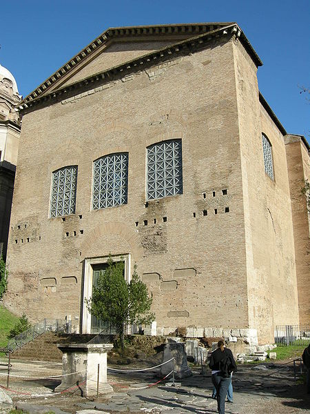
In cities where rulers live, they would have a palace. The homes of the richer nobility clustered around the ruler’s palace. The word palace comes from Palatine, one of the hills in Rome where that ancient city was founded and where its rulers lived.

In a more warlike society or one with external enemies, defense is a high priority, so cities might have a citadel. Literally meaning “little city”, this fortress usually sat on a hill within the larger city. Rulers had responsibility for the defense of the realm, so they often lived in these citadels, building palaces within them.

Often, the citadel was there first as a hill fortress. Often, a city grew around these fortresses as tradesmen and nobility settled nearby to take advantage of the protection of or access to the ruler.

File:Casale Monferrato map (018 003).jpg
See page for author, Public domain, via Wikimedia Commons

In more peaceful time, the ruler might abandon the need for a fortress and build a palace in a more serene setting. For example, the official residence of the Mughal Emperors in Delhi was the Red Fort, within which was the Chhatta Chowk bazaar and multiple palaces. Zafar Mahal, their summer residence, was in a hilly and wooded area in south Delhi.

Where a city included a large enough citadel, the nobility might be able to own a home within it. Prague Castle is such an example.

Peter K Burian, CC BY-SA 4.0, via Wikimedia Commons

In a more democratic society, there would less need for a citadel. Instead, you might find an assembly hall of the senate or public assembly. The ancient Roman Senate building was in the Forum, the central gathering place and market of the city.

File:Curia iulia 02.JPG
Curia Julia, Rome. I, Sailko, CC BY-SA 3.0, via Wikimedia Commons

Religious Centers and Temples

Religion played a major role in most human society throughout history and prehistory. As such, major cities had major religious centers as well. Even after Rome lost its place as the center of Roman political life, it retained its preeminence as the center of the Roman Catholic religion. The same is true of Mecca and Jerusalem.

In cities that are the center of a religion but not a government, the religious site becomes the focal point of the city. In medieval times Rome had no more than 100,000 inhabitants, but the Pope’s residence remained in the Vatican or Lateran palaces.

File:Chor Apsis San Giovanni Laterano Rom.jpg
Choir and Apse Saint John Lateran Rome. Stefan Bauer, http://www.ferras.at, CC BY-SA 2.5, via Wikimedia Commons

Jerusalem has been a pilgrimage destination Jews, Christians, and Muslims for thousands of years. Except for a 200 year period when the crusaders ruled the Levant, it hasn’t been the capital of a kingdom since the Babylonians captured it in 597 BCE.

Religious sites pepper the city, though the Temple Mount is the central focus, the site of the Western Wall, revered by Jews, and al-Aqsa Mosque, revered by Muslims. Christians have multiple holy sites, including the Church of the Holy Sepulchre. Any one of these would be a major draw as a religious center.

Jerusalem – Holy City for three world religions. Copyright dierecke.com

If you are designing a fantasy city with a religious focus, Rome or Jerusalem would be good models of cities with a single focus or multiple focuses.

Trade Centers

Wherever people congregate in large numbers, trade follows them. Cities that have religious, governmental, or defensive centers almost always have large markets as well.

Conversely, wherever trade goes, people follow it. some cities are trade centers but have no governmental or religious significance. This is less common in times of war and strife. Trade needs defense. In more peaceful times, trade can flourish.

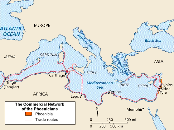
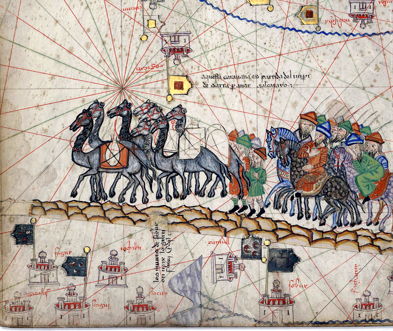
Cities whose main purpose was trade include Florence and Venice in Italy, Carthage in Tunisia, or Mumbai in India. Romans, Phoenicians, Greeks, and western Europeans built or developed many colonial towns for the purpose of increasing trade with the home country or city.

File:PhoenicianTrade.png
Yom (talk · contribs), CC BY-SA 3.0, via Wikimedia Commons

Multipurpose Cities

Some cities had multiple purposes, especially in societies where religion was closely tied to government. Constantinople, for example, served all three purposes. It was the seat of the Byzantine (late Roman) Empire, the seat of the Orthodox Patriarch, and a major trade center at the crossroads of Europe and Asia as well as the Mediterranean and Black Seas.

Baghdad under the Abbasids was the same, though for a different ruler, a different religion, and different trade routes.

Even when cities have multiple purposes, the palace, market, and temple normally cluster close to the center. Remember, the city center is usually not more than 1km across.

Rome, showing the temples on the Capitoline, the palaces on the Palatine, and the market of the Forum. Copyright mapaplan.com.

Residential Neighborhoods

Your city’s inhabitants will mostly live in the neighborhoods beyond the center. These neighborhoods usually cluster tightly together. There was nothing like the suburban sprawl that we see in modern cities. In addition to being crowded, these neighborhoods were usually dirty as well, with no running water or sewers.

Travel was by foot in the cities, though richer people owned horses. This limited the physical distance a person wanted to walk. If you take the rule that a person won’t normally walk more than 20 minutes for an errand, it keeps most day to day functions such as local food markets close.

Streets were normally about 10 meters across, wide enough for two carts to pass, though they were narrower in places.

The broad avenues of most major modern cities were built in modern times to ease congestion through the city, bypassing the narrow confines of the neighborhood streets. In the 18th and 19th century, city planners designed the radial patterns of of avenues in Paris and Washington DC with this in mind. Compare Paris in 1223 to 1702 to 1765, and finally 1874, when major routes were added. We see little change from 1223 through 1702, the beginnings of a radial street pattern in 1765 and a major change in 1874.

File:Erhard frères, Plan de Paris indiquant le tracé des voies nouvelles dont S. M. l'empereur Napoléon III a pris l'initiative, 1874 - Gallica.jpg
Paris in 1874 Bibliothèque nationale de France, Public domain, via Wikimedia Commons

In many preindustrial cities, tradesmen lived where they worked. Shops would front the street while the family lived behind or above the shop.

Larger cities such as Rome built multi-story apartment blocks called insulae (islands) to house residents. These were usually crowded and dangerous, contributing to disease and fire. Cities in China and pre-Columbian America also had apartment blocks, though they were not as crowded as in Rome.

Ostia: Plan of Regio III – Insula IX – Case a Giardino (Garden Houses) Source: smarthistory.org

Defense

As I said in my previous article, people live in cities for defense. For this reason, most pre-industrial cities built walls for defense. In peaceful times, this might not be as important and the population settled outside the walls, but when outside enemies threatened, the walls became quite important.

Some city walls were massive, such as those of Constantinople. Others were simply masonry or field stone piled on top of each other.

File:Walls of Constantinople.JPG
Restored walls of Constantinople. en:User:Bigdaddy1204, CC BY-SA 3.0, via Wikimedia Commons

Frequently, cities took advantage of water not just for personal needs but for defense, locating on islands in rivers or lakes. The Aztecs built Tenochtitlan in Lake Texcoco.

File:Map of Tenochtitlan, 1524.jpg
Map of Tenochtitlan, 1524. Friedrich Peypus, Public domain, via Wikimedia Commons

Water and Sewage

In addition to needing water, cities need sewers. Removing human waste and excess rainwater is a necessity for the health of the populace.

The Sumerians first used clay sewer pipes around 4000 BCE. The city of Uruk first used brick constructed latrines around 3200 BCE.

Waste removal in medieval Europe was sadly deficient. Usually, cities disposed of waste in open streams or ditches running through the city. This led to high mortality due to disease, plague and pandemic. Paris didn’t clover its sewer until 1370.

For the most part, the poorer neighborhoods lacked high quality sanitation. They were crowded and dirty.

Public Baths

On a week-long trip to Budapest once, I decided to tour all the public baths in the city. Maybe some day I’ll write about my experience in the Turkish bathhouse there, but not today.

Many ancient and medieval cities also had public baths. Cities in Rome, Greece, and as far back as Mohenjo Daro had them.

In ancient times public bathing included saunasmassages and relaxation therapies. Neighbors met and discussed community concerns in these communal places. Think of the cliché of the mafia don meeting his rivals or lieutenants in a public bath.

Public baths improve the health and sanitation of the city, but they require adequate public water supply and sewer systems.

Baths of Caracalla, Rome reconstruction. Copyright Avinash Kumar Srivastav

You don’t need to map out the sewers when designing your fantasy city, but you should decide how adequate the sewer system is and whether there are adequate facilities for bathing. Which of these models you want your city to follow is up to you. I like a cleaner city, but if your story wants a filthier, grittier setting, opt for the European model.

City Layout and Urban Structure

In designing a fantasy city, you will need to decide its geography. Where are all the main features in relation to one another? City layout and urban structure is a complex topic with many facets. It would be easy to get lost in the weeds in inventing a realistic city. However, one doesn’t need a degree in urban planning to design a fantasy city.

Scholars define five different city layout types: geomorphic, radial, concentric, rectilinear, and curvilinear. The most common ones were geomorphic, rectilinear, and radial. As an amateur city planner, you are free to invent your own as well. Just remember that people must live in your city. Even if they are fictional, they they will adapt the city you design to their own use.

Geomorphic

Geomorphic patterns follow the layout of the terrain. These are common where there is no central planning. In such situations, cities grow organically according to the needs of its inhabitants. People walk according to the route that requires the least expenditure of energy. My own home town of Sitka, Alaska is laid out in a geomorphic pattern out of necessity.

There is an urban legend that the settlers of Boston followed cow paths when laying out the streets. This is probably not far from the truth. Just looking at the map, one can see that it followed geomorphic patterns.

File:Boston, 1775bsmall1.png
Thomas Hyde Page, Public domain, via Wikimedia Commons

Rectilinear

Also known as the grid plan, rectilinear cities are the favorites of city planners. This plan is among the oldest of city layouts, from Mohenjo-Daro to Roman coloniae, to Chang’an, China, to Teotihuacan, Mexico.

The most familiar of these to students of European history was the Roman grid plan. The Romans founded multiple cities throughout western Europe as Roman colonies. One can still see the grid on the map of the city centers of Florence, Italy, Cologne, Germany, Zaragoza (Caesaraugusta), Spain.

As you can see from the maps, these cities grew beyond their Roman cores in stages. By studying the maps, one can see the rings of medieval, renaissance, industrial, and modern era growth.
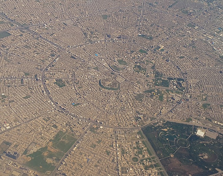
Radial

In a radial structure, main roads converge on a central point, usually a market or plaza. Cities such as Amsterdam or Erbil, Kurdistan follow this pattern. This radial pattern became popular in the renaissance and can be seen outside the Roman core of Florence.

File:Aerial view of central Erbil, Kurdistan.jpg
Aerial view of central Erbil, Kurdistan. Lamacchiacosta, CC BY-SA 4.0, via Wikimedia Commons

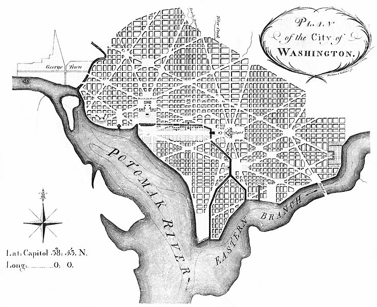
The radial plan needn’t have its focus on the center of the city. In larger cities, avenues might radiate out from satellite centers in neighborhoods, linking them together. Later cities such as Washington, D.C. combined the radial and grid plan in just this way.

Designing Your Own Fantasy City

Hopefully, this exploration of city structure and planning gives you enough ideas to design your own fantasy city. Remember that any city has to be used by people. Design has to conform to their needs. Whether you lay it out following terrain or in a grid, set up city walls, or have adequate water and sanitation, these factors will influence the people in it. The people living in a city also have their own ideas of how they use the infrastructure they are given.

Once you have the design of the city, you can start populating it. The major districts imply the existence of rulers, priests, and merchants. Once you understand the environment they live in, you have a better understanding of who they are and how they would act in certain situations. Once you have characters, you are well on your way to creating a fantasy story.

Final Comments

I will leave you with one of my favorite maps, though it isn’t a fantasy city. It is Berlin ca. 1855. It captures the development of the city from its founding up to that time. One can see the original medieval city in the center and the river that protected it. The imprint of the renaissance walls and moat surround the medieval core. Outside that are the rectilinear grid of Friedrichstadt and the radial pattern of streets in the northeast and by Hallesches Tor. The city at this point is encircled by a wall used mainly to collect customs rather than for defense. Outside that wall are the beginnings of industrial development in the train stations (bahnhofs). The city grew beyond these walls in the later 19th and 20th centuries to the city we know today.

Sansculotte (talk · contribs), CC BY-SA 2.5, via Wikimedia Commons
Comments closed

Worldbuilding 101 – How to Map your Fictional World

In my original Worldbuilding series, I covered how to draw maps for your fantasy stories. If you want a fully-fleshed out world for novels, movies, D&D, or other games, this is a great place to start. The Worldbuilding 101 series covers mapping a fictional world. The Worldbuilding 102 series will cover creating fantasy societies.

Click on the links below to see the articles

  1. Mapping Your Fictional World
  2. Continents & Plate Tectonics
  3. Climate
  4. Landforms
  5. Biomes

Comments closed

Worldbuilding 102 – Creating Cities in a Fantasy Society

Now that we know what our people look like, let’s explore cities in a fantasy society. Not literally explore them, just explore the topic. We didn’t necessarily need to know what the people look like in order to know where they live. This topic could have come first, but it is intrinsically bound with other topics we will explore in the next few articles.

Why and Where before the How

We’ll deal with the How, the actual layout of the city, in the next article. It is the level of detail that your characters interact with and is the bare minimum your will need for writing a story in an urban setting. Before we get to that, let’s look at the Why. Why do people settle in villages, towns, and cities to begin with? It’s possible the people in your world don’t live in cities at all.

On Earth, humans evolved on the savannahs of Africa and spread throughout the world during the Paleolithic period (old stone age). For 200,000 years, Homo sapiens lived off the land, hunting animals and gathering plants for food and textiles. While humans built shelters out of wood, clay, straw, they were mostly campsites for nomadic tribes.

File:Homo sapiens dispersal routes.jpg
Katerina Douka & Michelle O’Reilly, Michael D. Petraglia, CC BY-SA 4.0, via Wikimedia Commons

It is possible to write a fantasy story in a Paleolithic setting. The Clan of the Cave Bear series by Jean M. Auel is a great example.

Earliest Settlements

It was only in the Neolithic period (new stone age) that humans built permanent settlements. This coincided with the advent of agriculture about 11 thousand years ago with the climate warming at the end of the ice age. Farming began when hunting and gathering wild grains was not enough to support populations. The population grew in good times. When drought constricted food supply, people turned to farming to survive.

Farming required the farmer to stay in one area to tend to the crops. If the family moved elsewhere, another family might move in and harvest the crops the first family worked so hard to grow.

In this period, lasting for thousands of years, people lived in villages of about 50-100 people. Villages would be governed by the elders of the clans. The villagers were not subjects of a king, nor were they citizens of a republic, though a village might have headman as a leader.

The practice of farming spread as people migrated, taking agricultural techniques with them. Neolithic agricultural techniques and societies persisted among humans clear through the industrial revolution. Except for the introduction of iron tools and the rule of kings, the vast majority of peasants from ancient to medieval times lived an essentially neolithic lifestyle.

Centres of origin and spread of agriculture. Joe Roe, CC BY-SA 3.0, via Wikimedia Commons

Villages to Towns, City-States, and Empires

Villages grew larger in the bronze age. It was in this period that political power grew stronger, more organized, and more centralized. Hereditary chieftains or kings supported by a class of priests arose around this time. The king often acted as the chief priest or claimed the mandate of the gods. This was about the time of the Uruk period in Mesopotamia and the Zhou period in China.

Centralized power coincided with the development of organized irrigation. Agricultural technology allowed the accumulation of surplus food, which allowed a division of labor. This coincided with the advent of writing, which was first used to record accounts (Egypt and Sumeria) and as oracles (China).

Cities in Fantasy

The first question one needs to answer in planning cities in a fantasy society is whether there are cities at all. Humans developed agriculture in response to environmental stress. That led to writing and cities. Did the humans, humanoids, or non-human species of your world face the same pressures? In other words, Does your fantasy society need cities and towns at all?

Humans lived in nomadic tribes for hundreds of thousands of years in the Paleolithic era. One could imagine the Silvans of Pancirclea living in simple shelters in the forests, moving from place to place following the seasons or pursuing food sources. They would be uncivilized in the sense that they don’t live in cities, but that does not mean they wouldn’t have a complex culture. Perhaps they would not develop writing or smelting, but they might borrow such things from nearby civilizations.

Peoples of Pancirclea. Image by Michael Tedin

Development of Cities and Civilization in Fantasy

In your fantasy society, if you want to look at the history of cities and civilization on your continent, you really only need to go as far back as a Bronze Age. This is when cities on earth grew and developed the attributes of writing, smelting, and complex government. Also, this is when the first empires were founded.

On my map of Pancirclea, I started with an area where farming might have begun. It is a hilly area where a warming climate changed the biome from a fertile one able to support a large population to a less fertile one unable to support the same population. In this case, people developed farming to increase their food supply.

Over the course of hundreds of years, farming techniques spread, including irrigation in the river valleys, which involved more complex social organization and the foundation of what we now think of as cities. This is the core of civilization on Pancirclea.

Over time, they spread to other areas suitable for farming, sending colonies to relieve population pressure at home. These colonies encroached on the homelands of the Silvan people and Hillfolk, causing conflict and possible war. One can imagine the city people invading the Hillfolk lands to seize mines for metal ores. One can also imagine the Silvans attacking settlers who attempt to clear forests for more farmland.

Origins and spread of Civilization in Pancirclea. Image by Michael Tedin

Placement and Growth of Cities

We have answered the Why. Let’s look at the Where. Where are cities placed? Part of the answer depends on why the city is founded and the social conditions that it is founded under. Did it grow from a neolithic village or was it founded as a colony from another city? Was it a peaceful era with few external threats or were the founders worried about bandits, marauders, foreign armies, or other enemies?

Defense and Trade

The two main factors determining where cities grow are defense and trade. Cities are by their nature centers of trade, religion, and politics. Originally, they grew from towns as population increased. Technological innovations such as literacy, bronze smelting, and legal codes allowed economic diversity. Scholars have attempted to define a the origin of cities using characteristics similar to these.

On the other hand, many cities were founded intentionally, especially in later empires such as the Roman. Major cities such as Milan, Florence, Cologne (Colonia in Latin), and London were all Roman colonies. Many colonies were established for defensive purposes outside Roman territory. 

File:Image-Roman Cologne, reconstruction2.JPG
Nicolas von Kospoth (Triggerhappy), Public domain, via Wikimedia Commons

Many cities grew around military forts or castles, often forts of conquered people. For example, Colchester, England, Paris, France, and Cologne, Germany. Cities also grew around hill forts such as Prague, Czechia, Delhi, India, and the Kremlin, Moscow.

Trade Drives Growth

Trade routes allowed cities to grow beyond their original defensive purposes. Often, merchants settled near forts to take advantage of the protection of the military based there. This became the core of a new city. Trade was always the driver for the growth of cities. Cities along trade routes grew richer and larger. It begs the chicken and egg question: did the first cities grow along trade routes or did the first trade routes grow between larger towns? Whichever comes first, settlements grow where trade routes nourishes them.

File:Caravane sur la Route de la soie - Atlas catalan.jpg
Abraham Cresques, Public domain, via Wikimedia Commons

The two factors of defense and trade ebbed and flowed in importance depending on the conditions of the time. In warlike eras, defense became more important. Cities on hills or islands had an advantage during times of unrest. Cities better situated along rivers or across easily traversable terrain had an advantage during peaceful times when trade flourished. Those that had both, such as Paris or Venice, flourished under both conditions.

Everybody Loves a Water Feature

Another key need for the growth of cities is water. A large population needs fresh water to survive. For this reason, most large cities grow near plentiful water supplies, usually rivers. The first cities were along the Nile, Tigris, Euphrates, Indus, and Yellow Rivers. Sometimes, the cities built canals or aqueducts to bring water to them. Roman Aqueducts are still considered an engineering marvel. China’s second great engineering marvel is the Grand Canal, linking Beijing in the north to Hangzhou in the south.

Rivers and canals also allow increased mobility with boats and barges, increasing the ability to trade with other cities on the river.

File:Kaiserkanal01.jpg
Grand Canal (China) via Wikimedia

Common sites for Cities

Some of the most common sites for major cities are:

On islands in rivers. E.g. Paris, Cologne, Berlin, Syracuse, Sicily

File:Memhardt Grundriß der Beyden Churf. Residentz Stätte Berlin und Cölln 1652 (1888).jpg
Old Berlin and Cölln 1652 Johann Gregor Memhardt, Public domain, via Wikimedia Commons

At fords across rivers. E.g. Paris

File:107 of 'Notre capitale Paris ... Deuxième édition. (With illustrations.)' (11289701404).jpg
Lutetia (Ancient Paris), The British Library, No restrictions, via Wikimedia Commons

At river crossings suitable for bridges. E.g. London.

File:Map Londinium 400 AD-de.svg
Londinium (London) in late antiquity. Fremantleboy, CC BY 2.5, via Wikimedia Commons

At the confluence of rivers. E.g. Lyons, France, Erlitou, China.

File:Lugdunum Lyon 16xx.jpg
Lyon in the 17th century. Bibliothèque nationale de France, Public domain, via Wikimedia Commons

Hmmm. Is there a theme here?

Hill Towns

Not all cities are placed on rivers. As I said earlier, some were created around hill forts for defensive purposes. The hill towns of Tuscany or ancient Palestine were placed at the top of hills, but each of them needed an abundant source of water, usually from wells. These cities usually succeeded in times of social unrest or particularly warlike periods due to their defensive advantages.

File:San Gimignano Tramonto.jpg
San Gimignano Tramonto. Maurizio Moro5153, CC BY-SA 4.0, via Wikimedia Commons

Cities in a Fantasy Society

Again, placement of cities in a fantasy society goes back to the map. Find the area where civilization first developed. Cities in those areas will grow organically based on the factors of defense, trade, and access to water.

Next, look to where people would intentionally found cities as they spread from their home civilizations. What would be the best sites for colonies?

At this point, you might not have enough detail to determine where islands or fords in rivers might be. In Pancirclea, I placed cities where it looked like a good place for a kingdom or empire to grow, then drew in additional rivers and streams to provide water for the city. As the worldbuilder, you have the freedom to add detail as you focus in. When you do, pay attention to the guidelines set up in earlier articles, especially on landforms.

One hint for islands and fords is that water is generally shallower and islands form where rivers grow wide in low flat areas. Rivers are also shallower above river confluences.

One hint for islands and fords is that water is generally shallower and islands form where rivers grow wide in low flat areas. Rivers are also shallower above river confluences.

Placement of the first cities and trade routes in Pancirclea. Image by Michael Tedin.

Rather than naming my cities now, I gave them letter designations. Names are a function of language, so I’ll give them names that conform to the language of the inhabitants when I discuss that later. I’m pretty excited to get to that topic. I love conlangs (constructed languages).

Now we know where the cities of our fantasy world are and where the trade routes that link them lie. In the next topic, I’ll talk about the How of cities, focusing in on individual cities and their layout. What are the major features? How are the streets laid out?

5 Comments

Worldbuilding 102 – Creating Fantasy Societies – Humanoids and Non-Humans

Our exploration of worldbuilding humanoid and non-human groups is merely an extension of the discussion in my last article about fantasy demographics. The question is, what do the humanoids or non-human groups in your fantasy world look like, if you have any.

Avoiding Cliché

In my own story writing, I have left out elves, dwarves, halflings, and orcs. It is such a staple of fantasy that it is hard to create a fantasy species that is not a cliché or a knock-off of Tolkien or Dungeons and Dragons.

In defining the races of Pancirclea in my last article, I specifically created them so they could be quickly converted to humans, elves, and dwarves if I wanted. Savannah people would be humans. Add a few features to distinguish them such as pointy ears on the Silvans to turn them into elves. Make the Hill people short and stocky and they become dwarves.

This image has an empty alt attribute; its file name is image-4.png
Pancirclea Humanoid Distribution. Image by Michael Tedin

There is a way to put these species into your writing without it being cliché, but it is difficult. It has been done so many times that a new kind of elf or dwarf would be difficult to come up with. You will have to draw on all your creative power to come up with something original. Hopefully, this article will help.

Humanoids

First, we should define what a humanoid is. In my mind, it is a sub-species of human, closely related enough to interbreed but different enough to be considered not quite homo sapiens sapiens. Maybe elves are homo sapiens nobilis?

Second, the basic body shape is human. That is, a central torso with two arms coming off the shoulders, a head on top, and legs about as long as the torso coming off the bottom.

Image of humans from plaque aboard Pioneer 10 and 11

Humanoids should conform to this basic body shape. Any deviation from this should be classified not as humanoid, but as non-human. More on them later.

The point of humanoids is to have a creature that is human enough to relate to but with enough of a sense of otherness that they are not quite right. Often, having such creatures creates a sense of wonder and mystery, which is why they are used so often in fantasy.

Humanoid Features

Similar to our discussion of fantasy demographics, humanoids follow a similar set of features, with a few added features to include.

That is, when creating humanoids for your fantasy world, create charts of skin color, eye color, hair color, and hair texture. With humanoids, everything will be fictional, so feel free to add more fantastical elements. Give them blue, orange, or green skin; yellow, purple, or pink eyes.; or different colored hair. Really, anything goes at this point.

When doing so, think about analogies to human genetic variance. Perhaps green skin evolved in certain areas due to magical background energy. This genetic group might slowly mix with other groups outside that area, creating a higher concentration of green skin in the area, with a gradual decrease in prevalence farther away.

You can come up with whatever explanation you like, just so long as it keeps things consistent in your fantasy setting. You don’t have to explain the underlying reason for it. People didn’t fully understand human genetics for most of human history or pre-history. The purpose of creating a reason is so you can keep things straight in your own writing without unexplained divergences from your fictional norm.

Humanoid Differences from Humans

What really sets humanoids apart from humans? Along with the features discussed above and in the fantasy demographics article, there are things that differentiate the two groups.

The most obvious and cheapest for movie and TV makeup departments to create are pointy ears, big noses, and ridged foreheads. The main things that you can alter from the basic human shape are the head and hands.

And big hairy feet.

Elijah Wood as Frodo. New Line Cinema

I get the sense that so many fantasy and science fiction creatures in movies and TV are created with human body shapes is because it is the cheapest way to create aliens.

Humanoid Size

Other features that might differentiate humanoids from humans are size. Dwarves, hobbits and sometimes elves are smaller. Giants are larger, sometimes much larger. The basic body shape is the same, but fantasy has either made them huge or tiny to create a sense of otherness.

The range of humanoid size reaches from mountain-sized (giants), to thumb-sized or smaller (fairies and pixies). On the other hand, I would argue that fairies and pixies are not humanoid because they have wings.

Garden gnomes, on the other hand, would be humanoid. Also, they love to travel.

Roaming gnome on safari. Travelocity

Creating Humanoids from Other Species

Another common trope, especially for TV, is to create humanoid species from animal species. Again, in movies and TV, it is common because it is cheaper to get a human actor with a mask to create a monster.

But even in written works and games where there are no such budget constraints (unless you hope to sell your novel to Hollywood), we find humanoid creatures based on other animals. Perhaps you’ve heard of the Kzinti, a cat-like species in Larry Niven’s Known Space series. There are also lizardmen and dragonmen in game settings. In my own writing, I have created dog-men, though they did not evolve, but were created.

One might make an argument that these creatures are not humanoid, but non-human in human shape. I would argue back that, according to my definition, they are humanoid because they keep the same basic body shape. On the other hand, there seems to be a gradation between humanoid and non-human species. At what point does a change in body type make a creature no longer humanoid?

Non-Humans

When talking about non-humans in a fantasy setting, I specifically mean non-human sentient species. These are intelligent creatures able to communicate and reason similar to humans.

See the source image
Dragonkin. Image by Coobra, Wowpedia.com

The definition of what makes a creature sentient is open to philosophical debate.

Sentience is a multidimensional subjective phenomenon that refers to the depth of awareness an individual possesses about himself or herself and others.

L. Marino, in Encyclopedia of Animal Behavior, 2010 from ScienceDirect.com

There are those who would argue that humans are the only known sentient creatures. There are also those who argue that our definition of sentience is constrained by the fact that we only recognize our own intelligence and are unable to comprehend a non-human sentience.

Whew! Let’s not get too deep into the weeds here. Maybe when I was 30 years younger and under the influence of controlled substances I would have this discussion. I probably did.

The purposes of fiction, let’s define sentience as an intelligence that is able to communicate with humans in some manner. Perhaps the plot of your story is your characters’ struggle to understand the alien species, but the potential for communication is there.

What is Non-Human?

The real defining feature of a sentient non-human species is body shape. Going back to the races of Pancirclea, if we wanted to go further than to turn Hill people, Silvans, and Savannah people into dwarves elves, and humans, we could alter their body shape.

Think about how each race’s unique environment might change them over the course of 100,000 years. If the Silvans lived in trees, perhaps they would use their arms to climb more than their legs. Humans developed long legs from running across open fields. Silvans would not do so. Perhaps their legs would be shorter and their arms longer, similar to other tree-living apes.

Add feet with opposable thumbs to aid in climbing and you’ve got a hairless, sentient forest ape similar to a chimpanzee or bonobo.

Similarly, perhaps the Hill people have adapted to the mountainous environment by living in caves. I’m having a hard time imagining how they would evolve a different body type other than something similar to a dwarf, shorter with powerful arms and legs. Maybe you have a better imagination than I do. I’d love to hear your ideas.

Other Body Types

Similar to the dragonkin in the picture above, you can create a range of sentient species based on other species. One might argue that the Kzinti, lizardmen, and dragonmen mentioned above are better classified as non-humans than humanoids.

Any body shape you can imagine can be made into a sentient creature, from animals similar to humans to as alien as jellyfish. I recently read Binti by Nnedi Okorafor. In it, she created a race of Medusae, a jellyfish-like species the main character interacts with. The creature is as alien as they come, but still sentient, rational, and honorable.

Character Driven Differences

The potential for creating weird and unusual creatures in your fiction is as broad as your imagination. However, think about why you want to put such creatures in your stories. Is it just to flex your imagination muscles? If so, your efforts may fall flat in your writing.

Think about your story and your plot. Plot is driven by characters. If your characters are humanoid or non-human, think about what difficulties those differences create for them. If they are interacting with humans or other humanoids or non-humans, do the differences create conflict? Conflict is the heart of plot.

If your creatures are simply humans with fancy face makeup (or hairy feet), what is the point of making them different? They become nothing more than set dressing. You might as well make your characters all human.

Your Thoughts

Feel free to respond with ideas. What creatures have you created? What drives them? How do they interact with other species or members of their own species?

Comments closed

Worldbuilding 102 – Creating Societies in a Fantasy World – Demographics

Demographics

If you are worldbuilding for fiction, either as a game or as a novel, you need people to inhabit your world. Your primary concern should be your main characters. They are what drives your plot. Similarly, you need minor characters for your main characters interact with. Fleshing out your fantasy demographics allows you to create characters the reader can relate to. Where do they come from? What is their family history?

Demographics tell us what the people in a certain population are like. It is defined as “the statistical characteristics of human populations“. Among most demographers, two of the main categories of demographics are race and ethnicity.

Race and ethnicity are somewhat artificial divisions in a society. Race is a social division based on physical characteristics, while ethnicity is a more narrow division based on racial, national, tribal, religious, linguistic, or cultural origins. I will discuss the factors that make up ethnicity in later articles in this series.

Keep in mind that these guidelines are just that. Focus on creating compelling main characters first. If for some reason you have a good story reason to deviate from the worldbuilding rules you create, story should take precedence. If you do deviate, it would be best to find a reason in the rules you have created. What would be better would be to make the deviation a plot point.

For this article, let’s focus on race as expressed by physical characteristics. I will also expand on physical characteristics to look at the fantastical elements such as human sub-species, humanoid species, and non-human sentient creatures in a later article.

Physical Characteristics

When talking about the physical characteristics used to define the demographics of a race, modern humans look at things such as skin color, eye color, hair color, hair texture, and body size.

Of these, skin, eye, and hair features are mostly determined by genetics. The role of genetics versus environmental factors in determining human body size is a matter of great debate.

Mutations as a Source of Genetic Difference

Humans are widely believed to have evolved in the hot, open environment of the plains or at least, a tree-dotted savannah. Later on, with the invention of tools such as clothing, they moved to other environments.

World map of prehistoric human migrations, according to mitochondrial genetics. Wikimedia Commons

Of course, such migration took place over the course of millennia, allowing greater variation in genetic diversity. Populations that are further apart geographically and ancestrally are more genetically distinct.

Mutations rose in distinct populations that affected appearance among other things. As an example, the stereotypical northern European has different hair color and texture, eye color, and skin color than a typical aboriginal Australian or American Indian.

Genetics and Racial Mixing

Contrary to much of what was taught through the history of the United States, racial divisions are not hard and fast. Rather, they are a social construct loosely related to genetics. Some scientists say that race is a poor description of genetic diversity.

In the United States historically, anyone with “one drop” of African blood was considered Black. This is a rare definition and was originally used to justify enslaving Negros in a time when any enslaved person in the United States was a Negro.

Consequently, in the rest of the world, such a definition confuses people. Most cultures other than the United States accept that different genetic groups mix. In such cultures, the offspring of a mother and father from two different racial groups would be called a creole, mulatto, or mestizo.

Through such mixing, different physical characteristics disperse throughout human populations. For example, the concentration of blue eyes in Europe is heaviest around the Baltic Sea and disperses in the population farther away from the sea.

Concentration of blue eyes in Europe Dark Tichondrias at the English language Wikipedia, CC BY-SA 3.0, via Wikimedia Commons

For the purposes of fantasy demographics, we will use race as exactly what it is: a social construct. In later articles, we will look at how it influences economics and culture. For now, we want to examine the physical characteristics used as markers that signify race.

Genetic Mixing and Migration

The more humans move from place to place, the more mixed populations will be. With little genetic mixing, mutations might become dominant only in certain groups. On the other hand, with mixing, the mutation becomes shared. In the blue eyes example above, if Vikings didn’t raid, there would probably be fewer blue eyes in northern Britain and Ireland than there is now.

In the modern age, with world travel available to people from every country, the opportunity for genetic mixing is the highest it has ever been. Prior to the era of ocean-going ships, railroads, and flight, travel was mostly by foot. In those times, people did not travel great distances in large numbers very often. When they did, their migration was constrained by the natural environment. Mountains, rivers, lakes, and seas all did their part to limit and direct the movement of peoples.

Human Demographics

When creating your own fantasy demographics, use the map you created in Worldbuilding 101. Firstly, look at your landscape and see where the natural features that divide and direct people are. Any division will work. Northern vs southern populations, if distant enough are not likely to mix. East or west sides of seas, rivers, or mountain ranges usually have less mixing.

Next, take into account whether seas and rivers allow for greater movement of people or less. Obviously, boating cultures are more likely to spread their genetics across bodies of water than landlubbers. The Viking example mentioned above is a case in point.

In addition, mountain passes allow movement of people, but usually only in narrow bands. When the Lombards moved into northern Italy, they brought their Germanic genes with them, settling on the fertile plain of what was up to then Cisalpine Gaul. Since their arrival, the region has been known as Lombardy.

Fantasy Demographics and Races

The history of human evolution and genetics is very fascinating, you say, but what does it matter in a fictional world that doesn’t have Vikings, Africa, or aboriginal Australians? If it doesn’t, you have to ask yourself, does it have people with blue eyes, black hair, or green skin?

These human mutations happened in the real world (except green skin), but they don’t have to have happened in your own fiction. You could just as easily have a race of red-eyed, blue-skinned people as have races that mimic real-world human evolution. Keep in mind that, the further from real-world phenotypes you diverge, the harder it will be for readers to relate to the character. Usually, writers cast these more fantastical characters as villains, though not always.

If you do create characteristics not found in the real world, think about how the feature might have evolved. Why do forest people have green skin? Yes, I am kind of on a green skin kick. Perhaps some algae or chlorophyll DNA got mixed into their own DNA. Additionally, perhaps green camouflage allowed for natural selection among the various predators in the jungle.

Racial Divisions in your Fantasy World

By racial divisions, I don’t mean racial strife, but what natural genetic markers differentiate one group from another? For illustration, let’s look at three groups in southeastern Pancirclea: Hillfolk, Silvans, and Savannah People.

Pancirclea Racial Distribution. Image by Michael Tedin

I chose these three based on the environment that divides them. I could also have chosen sea peoples or marsh dwellers. Maybe I’d do that if I were to set a story in those areas. For illustration, I’ll limit it to these three.

I’ll make a further distinction between the northern and southern Savannah People. I could also make distinctions among the various Hillfolk divided in each of their valleys, but let’s keep it simple for now.

Skin Color and Evolution

Among the people of the real world, skin color is probably the most prevalent marker of race, though other features also are used. The second most used feature is eye shape. For example, most East Asians have an epicanthic fold.

Humans evolved different skin colors over millennia. Dark and light skin correlate closely with geography and the sun’s ultraviolet (UV) radiation. Originally, humans had dark skin. Later, they evolved white skin when they moved to higher latitudes with lower UV radiation. Of course, human migration and genetic mixing has moved these skin colors to every location on Earth.

Tobus2, CC BY-SA 3.0, via Wikimedia Commons

This doesn’t mean that every person in a population will have the same skin color. Because of the proximity of different groups, there will be some variation of skin color within a population to account for mixing between the groups.

One of the most common classifications of skin type is the Fitzpatrick Scale, listing color from Type I (very light) to VI (very dark). These six classifications are described differently by different users. That is, the various descriptions for each classification are various synonyms for shades of black, brown, tan, and white.

Skin types from Skinsolutions.md.

Fantasy Demographics Skin Types

When creating my Dungeons and Dragon campaign, I created charts similar to the charts in the old AD&D 1st Edition Dungeon Master Guide. I still use it for minor characters in my novels. The chart below creates a distribution of skin colors for different populations in Pancirclea based on the Fitzpatrick Scale.

Skin ColorIvory (I)Ruddy (I)Fair/Pale (II)Beige (III)Light Brown (IV)Dark Brown (V)Black (VI)Special
Northern Savannah1-2223-4142-5556-8081-9091-9697-99100
Silvan1-1920-2930-5152-7677-9091-9697-99100
Hillfolk1-1011-1314-3334-5354-7576-9091-96100
Southern Savannah1-34-45-2627-3536-6061-7980-99100
Skin Color of Races in Pancirclea. Copyright Michael Tedin

As you can see in my chart, the southern Savannah People have a much greater distribution of dark skin than do the northern Savannah People. The southern Silvans probably also have a similar distribution vis-a-vis the northerners. Maybe they don’t because they get less Vitamin D due to lower levels of ultraviolet radiation underneath the forest canopy.

I kept this chart simple for the purposes of this worldbuilding demonstration. If I were going to be creating fantasy demographics for a novel or game, I would likely want to add more detail. For instance, I would divide each of the three groups into northern, central, and southern divisions, weighting the skin color of the southern divisions more heavily to the Black (VI) skin color and the northern divisions more heavily to the Ivory (I) or Fair/Pale (II) colors.

I also added a Special category to account for mutations. Examples of special skin types might be mutations, albinism, vitiligo, or diseases such as leprosy. I created an additional chart for special outcomes.

Special:
Grey1-30
Pink31-60
Yellowish61-85
Bluish85-100

Hair Color

Another major distinguishing feature of a race is the prevalence of certain hair colors. Almost everybody knows the most basic colors: grey, blond, red, brown, and black. There are other subdivisions and scales, but for our purposes, we can keep it simple.

Black is the most common human hair color. It is a dominant trait in humans. Brown is the second most common color. Blond hair is most commonly found in Northern and Western Europeans, but many Melanesians also carry a gene giving them blond hair. Also, northern and western Europeans are most likely to have red hair, but it is the rarest of all colors.

White and grey hair is more prevalent with age because hair loses pigmentation as people age. Other conditions might also cause a person’s hair to go white.

Human Hair Colors on Pancirclea

 BlondRedBrownBlackSpecialSpecial:
Northern Grasslands1-3031-3233-6263-9091-100White
Silvan1-2021-2122-5152-9091-100Grey
Hillfolk1-2526-2627-4647-9596-100Bald
Southern Grasslands1-1516-1617-3132-9091-100Bluish
Greenish

Human Hair Textures

Just as with color, you must keep in mind the variety of hair textures. These textures are found in almost every human population, though some are much more common than others. For example, the typical Japanese person would have straight hair, but wavy is also common. Kinky is very rare in Japan unless the person is of mixed race.

Hair Textures from Kontrol Magazine

The image above shows finer detail than we need for creating fantasy demographics. I simplified it so the numbers correspond to categories: 1: straight, 2: wavy, 3: curly, and 4: kinky.

Hair TextureStraightWavyCurlyKinky
Northern Grasslands1-2021-5051-8586-100
Silvan1-3536-6565-8586-100
Hillfolk1-2021-5556-8586-100
Southern Grasslands1-1516-3536-7071-100

Remember that these charts are for demonstration purposes. You can mix them up for your fantasy demographics as you want. Feel free to add more sub-categories of color and texture or change the distribution. Perhaps you want one of your races to have more red or blond colors to set them apart from the rest.

Eye Color

Now that we have skin and hair colors defined, we can turn to eye color. This should be the simplest physical feature to define. Seventy-nine percent of all human eyes are brown. Conversely, that leaves a minority of mutants descended from one person somewhere in northern Europe.

For those of us of northern European descent, we think of eye color as having a wide variety, but it is not. In fact, only 2% of the world has green eyes and about 10% have blue eyes. Other colors are Hazel, Amber, and Grey. Those might be categorized together with blue or brown, depending on your preference.

For fantasy demographics, you can use any eye color you wish, but your characters should be relatable. You can make green, blue, or grey eyes more prevalent than the real world. I will let you create your own chart for this among the populations of your own world.

Height

When talking about body size, we are mainly talking about height and weight. Humans all fall within a certain a size range. There is some variation mainly due to nutritional factors, which may also be related to climate and latitude. That is, in areas with fewer edible plants and animals, people may be shorter and thinner. People in mountainous areas often also have smaller stature due to food insecurity and poor health.

File:Male Stature vs Age.svg
ADSLLC, CC BY-SA 3.0, via Wikimedia Commons

As we can see from the chart above, most human males are between 160 and 190 cm (5′ 3″ to 6′ 3″) . Similarly, most human females are between 145 and 175 cm (4′ 8″ to 5′ 9″). There are many cases of people falling outside those ranges an inch or two or in the case of dwarfism and gigantism. However, these are fairly rare. Dwarfism and gigantism are usually due to hyperpituitarism, genetic disorders, or growth hormone deficiency.

Weight

Height is the main determinant of a person’s ideal body weight. If the average male is 175 cm, then his ideal body weight would be 70.7 kg (155 lbs). However, weight fluctuates depending on a person’s genetic background, metabolism, eating habits, and activity level. Average weights for men in the world range from 55.4 kg in Afghanistan (122 lbs) to 99.4 kg in Tonga (219 lbs). Extreme weights have been found from 2.13 kg (4.7 lbs) to 635 kg (1,400 lbs).

The variation here is so wide, you can set just about any weight for a person within these parameters.

The simplest way to describe sizes is by size categories rather than specific measurements. For example, you could use categories such as tall, medium, short and light, medium, heavy. If you really want to get specific, you can create charts similar to the skin, eye, and hair charts I created.

Races and Racism

One thing to be careful of in discussing human races is the tendency to attribute certain features to a person depending solely on their membership in a particular race. For example, in political races in the United States, there is the assumption that, because you are black or Latino, you will vote for Democrats. The Democrats learned the hard way that this is not true.

Throughout American history, racist views have ascribed certain attributes to African Americans based on their race that were more likely due to the socio-economic status they were forced into.

Above all, be clear in your fiction that the classification of people into races is based on a few features, not that the classifications determine those features. We are creating fantasy demographics, but we don’t want to be drawn into real-world biases.

Remember that race is a social construct that might affect other aspects of your society, especially economics. When we get to that topic, we will cover such issues as economic stratification, caste, and class.

Sub-species and Non-Humanoid Species

We have been talking about the genetics that create the wide diversity in human populations, but there are more species found in fantasy literature than just homo sapiens. The classic Tolkeinesque fantasy includes goblins, orcs, elves, and dwarves, among other things. I had planned on covering this topic in this post, but there is a lot of rich material to be mined there. I think it merits its own post. Look for it in the next week or two.

Comments closed

Worldbuilding 102 – Creating Societies in a Fictional World – Overview

In the next part of the Worldbuilding series, I will talk about society worldbuilding. I could have made this series part of Worldbuilding 101 and made this Part 6, but I wanted to create a mental break from the first part of the series.

As an aside, I just watched the movie La La Land where Mia meets a Hollywood writer at a pool party who has “a knack for worldbuilding.” She cannot get away from him fast enough. LOL! I guess the moral is that we all find this stuff fascinating, but it’s not really party small talk.

Image: The Golden Globes

With that as the backdrop for our social setting, let’s get on with it!

Physical vs. Social Environment

Up to this point, this series has focused on the physical environment of your fictional world. From here on, we will be talking about the social environment of the world.

There is a mental distinction we make between “The Environment” and human society. In our minds, anything not related to human society is “The Environment”. In fact, there isn’t a real distinction between them. One influences the other. We interact with our environment and our environment determines how our society develops and functions.

You might have thought my focus on plate tectonics was too much detail for worldbuilding. In fact, geology has a huge impact in our lives. As one example, there is a famous study showing how cretaceous geology influences voting patterns in Alabama millions of years later.

What Makes Up a Society?

In this part of the series, Worldbuilding 102, we will look at how societies form and how they function. This is important for writing fiction. As you develop characters, you need to know the world they grew up in and what influences they had on their lives.

We’ll try to answer the question of what the are people like. What do they look like? Where do they live? How do they think and talk? What do they eat and wear?

In doing so, we will use what we learned in Worldbuilding 101 and build on it. Keep in mind that, just as in the physical environment, these topics do not stand alone. Each influences the other. When society worldbuilding, you can’t design one piece without having some knowledge of the others. Take it all in, do plenty of research before finalizing anything.

We’ll do a quick overview of the topics here. I’ll go into greater detail in separate articles for each. They might get pretty complex the further in we go. I’ll try to keep each article short enough that you won’t have to wade through too much detail. If it gets too long and complex, I’ll break the topic up into multiple articles. I can see that happening for language, which is one of my favorite parts of worldbuilding.

Lists of Society Worldbuilding Topics in Future Posts

These are the topics I plan to cover. Note that there might be more than one post in each topic.

Human Demographics
Humanoids and Non-Humans
Settlement patterns (Villages, Towns, Cities)
Designing Fantasy Cities (Urban Geography)
Magic and Technology (Resources, Knowledge, Magic)
Economics
Types of Economies and Trade,
Money and Banking,
Caste, Class, and Clan
Language
Sounds and Phonemes
Words and Morphology
Culture
Architecture
Art
Clothing
Food
Philosophy & Religion
Government (Politics, Law, Military)

What About History?

History is not a separate topic, but permeates each other one. Each area of society developed over time. Just as we think about how each topic influences the others, we need to keep in mind how things change over time.

We’ll work through each topic keeping in mind the historical development of each area. I’ll use 10,000 year timescale. Longer time scales mean more detailed and complex cultures, though much is forgotten in just 3 generations. Think about it, if writing hasn’t developed, the only way for people to remember the past is for someone to tell someone else. When your grandparents die, they can’t pass on what they know. Only the important information is remembered. That is, what keeps you alive from day to day.

Society Worldbuilding for Fantasy

Remember that the world and societies we are worldbuilding are fictional and intended for a fantasy setting. That means that you can create and invent and make shit up as much as you want. the purpose of this series is to provide guidelines for how to invent something without it going off the rails.

Following the rules for how the various aspects of the environment and society interact makes your world more relatable to the reader. It provides a depth to the setting that readers like to explore.

Feel free to break the rules when you think it aids in telling your story. Just make sure that, if you do, you have a good reason for it. It is the broken rules that make for the interesting stories. Why does the dragon live in a desert where there isn’t enough food for him to eat? Why do the submarine people come out of the sea to trade on dry land? There should be a reason for these things other than you wanted to have a dragon or sea people in your story.

Keep these things in mind when you invent the world, before you start writing or even after you have started. We’ll start with demographics in my next article.

Are there any topics you think I missed? What areas would you cover?

Comments closed

Worldbuilding 101 – How to Map Your Fictional World – Biomes

Welcome to the last post on mapping the physical environment of your fictional world. I will have more posts in the worldbuilding series when I get into fictional societies. We’ve already covered the topics of map projections, continent formation, climate, and landforms. Today, we talk about biomes.

What the Heck Is a Biome?

A biome is a community of plants and animals that give the area an environment with common characteristics.  When people talk about “the environment”, biomes are what they are usually referring to. This environment gives your setting its atmosphere. 

It’s a common trope to start stories in safe environments and move them to exotic locales when the story gets going. Familiar environments are perceived as safe. Exotic locales offer more danger.

Keep in mind that what is familiar to one person might not be to another. For example, to most Americans and Europeans, the civilized farmlands and cities in those temperate zones would be familiar, while the Australian outback would be exotic and dangerous. It is widely recognized that everything in Australia is trying to kill you. An Australian might disagree with this.

The exotic doesn’t need to be far away. For example, the wild forests (mostly extinct) of Europe and North America were the source of a lot of anxiety among inhabitants nearby. They were the inspiration as the source of danger in many fairy tales and fantasy stories. Think of the wolves of Little Red Riding Hood and Peter and the Wolf.

General Types of Biomes

Biomes are found in three general types: Forests, Grasslands, and Deserts. Generally, the wetter the climate, the larger the plants. Shrubs grow in all types and are the transition between each. They are usually found in drier areas.

In this article, I focus on terrestrial environments, not aquatic, except where they intersect in mangroves and marshes. If you want your setting in an aquatic environment, there are some notes at the end of this article for you to do more research.

Climate and Its Effect on Biomes

We covered climate in an earlier article, but while climate affects the natural environment and often determines what kind of flora and fauna exist in an area, they are not synonymous.

These general types of biomes turn out differently depending on the climate. For example, hot and warm climates produce tropical, subtropical, and hot desert biomes. On the other hand, cool and cold climates produce temperate, sub polar, and polar biomes.

Moisture also plays a large role in determining the biome. Generally, the wetter the climate, the larger the plants and animals. This is why we usually find forests in moist climates, though we also find dry forests in some dry climates. This is because in those areas, seasonal monsoons provide enough moisture for at least part of the year.

Moisture also plays a role in biological diversity. More arid regions have less diversity.

Also, generally, the warmer the climate, the more diverse the ecosystem, so long as the moisture levels are comparable. That is, tropical forests are more diverse than northern forests.

Worldbuilding Biomes

So how does this play out when worldbuilding and mapping biomes onto your fictional world? I used the World Wildlife Fund biome definitions and mapped biomes onto corresponding climate zones. See below or here for links to some ecoregions. These links will have detailed lists of biomes. There are other systems you can use as well.

The biomes are broad classifications of very distinct ecosystems. Certain biomes might cross different climate zones, but are generally associated with a few related climate zones. Different biomes classifications might look different depending on the climate or location. This provides opportunity for a lot of creativity for the author, depending on the atmosphere one wants in the book.

They way I went about it was to look at my climate map, figure out where forests, grasslands and deserts would go based on drier or wetter climates.

Forests, Grasslands, and deserts of Pancirclea. Image by Michael Tedin

Focus on the Details

Next, I homed in on the biomes. That is, which biome would be appropriate based on the Köppen climate system? As an example, I focused on a couple of biomes and how I mapped them. This is a pretty loose application of theory to practice. There will be plenty of opportunity to drill down to specific details when you plan your actual story. Above all, you want to create a general atmosphere for your setting.

The tropical and subtropical moist broadleaf forests develop in moist tropical and subtropical climates: Af: Tropical rainforest climate, Am: Tropical monsoon climate, and Cfa: Humid subtropical.

The first of these climate/biome pairings, the tropical rainforest, is the classic jungle most similar to the Amazon or Congo basins. Likewise, the tropical monsoon forest is similar to Vietnam; Miami, Florida; or Yucatan, Mexico. The humid subtropical forest is similar to southern China.

Tropical and Subtropical Dry Broadleaf Forests

I’ll do one more just because I did the research and I find in an intriguing environment. The tropical and subtropical dry broadleaf forests is not what you typically think of as a tropical forest. Instead, it is seasonally wet and dry, changing as the intertropical convergence zone moves north and south. The trees in this biome are mostly deciduous.

These dry broadleaf forests develop in tropical savanna and hot semi-arid steppe climates.

As an example of a dry broadleaf forest in a tropical savannah climate, look to Thailand, Cambodia or Tamil Nadu in India. Additionally, you would find a dry forest in a semi-arid steppe in the Gran Chaco of Paraguay or the Deccan Plateau of India. For some reason, I am intrigued by the India-like environment. I think a fantasy story set in a mythical India-like world would be a fascinating read.

Flora and Fauna

Once you have these biomes mapped to climate, you can decide what actually lives there. Figure out what kind of plants and animals live in the area. What are the main identifying flora and fauna? You don’t need an exhaustive list, just the main ones that give the right feel for the environment.

When deciding on flora and fauna, use real-world examples to mimic your fantasy world. For areas you want to actually as a fantasy setting, you’ll want more detail. Research some of the ecoregions the World Wildlife Fund uses to define the environments of the various biomes.

For example, in the Mediterranean forests, woodlands, and scrub, the typical flora is oak and pine trees. The typical fauna is the small mammal: badgers, small catsmongoose, and mice. The Mediterranean biome is also home to larger animals such as gazelles, sheep and goats, and wild dogs like the jackal and hyena. Wild boars are common in Italy and Spain. Don’t forget birds such as vultures and eagles.

Fantasy Plants and Animals

If you are worldbuilding a fantastical world, you might want fantastical flora and fauna. You can create new plants and animals that we see in the real world but are adapted to a different environment. Animals adapt an move around. Climates change. Polar bears became brown bears when the ice retreated.

Maybe a bear the size of a cat or mouse could evolve in the desert. Maybe fast-running flocks of lizards similar to dinosaurs evolve in grasslands. Don’t get too carried away. Mushrooms require a lot of moisture so you wouldn’t see large masses of them year-round in the desert, though you might see them after a rare rainstorm.

Put as much detail into the areas you want to use in your stories. Focus on the areas that you want to use as a setting. It helps to have an idea of what other options are there in case your characters travel to a different part of your world. Feel free to use real-world examples as a short-cut. 

Remember though, that fantasy is all about the non-mundane, so the fantastical elements of your world might be these environments. To do it properly, take the biome and create something new. That is, invent a new plant or animal that would fit in the environment. It might take some real research into biology and environmental science.

If you do decide to create a fantastical biome, make it part of the story. That is, there should be a story reason for the difference from the real world. Exotic fantasy animals for the sake of making something up often feels forced. However, if there is a story reason for the change, it makes the story much richer and likely you will come up with something original.

Monsters

The next step in worldbuilding your biomes is to populate them with monsters. What kinds of monsters live in that environment?

Werewolves and werebears might be common in temperate forests, while giant lizards or snakes might be common in jungles. You might find fire-breathing creatures in deserts, but not likely in polar regions. Don’t put a colony of giant frogs in a desert unless there is a localized source of water. Even then, the colony would not be large.

Next, think about what creatures are sentient. For instance, are humans the only sentient creatures or have others become sentient? Think about lizardfolk in tropical forest biomes or Rakshasas in the tropical dry forest (for an India-like setting). Centaurs might develop sentience in the grasslands and steppes.

You could also leave off the exotic monsters and use the most dangerous monster of all: humans. Have humans evolved into multiple species? Think of the elves and orcs of Tolkien. For those that want to avoid that cliché, you can create other types of sub-species adapted to particular environments.

Once we know what sentient creatures live in what areas, we can start to focus on how their societies are organized. That will be a complex set of topics covered in the next set of articles in the worldbuilding series.

Biomes mapped. Image by Michael Tedin

Resources for Further Research

Find Wikipedia’s Outline of Biomes here.

Terrestrial Biomes

Polar/montane: Tundra Taiga Montane grasslands and shrublands

Temperate: Coniferous forests Broadleaf and mixed forests Deciduous forests Grasslands, savannas, and shrublands

Tropical and subtropical: Coniferous forests Moist broadleaf forests Dry broadleaf forests Grasslands, savannas, and shrublands

Dry: Mediterranean forests, woodlands, and scrub Deserts and xeric shrublands

Wet: Flooded grasslands and savannas Riparian Wetland Mangrove

Aquatic Biomes

Pond Littoral Intertidal Mangroves Kelp forests Coral reefs Neritic zone Pelagic zone Benthic zone Hydrothermal vents Cold seeps Demersal zone

List of Biomes Cross-Referenced to Climates.

With Real-World Examples

A.    Polar and Subpolar

1.    Boreal forests/taiga

Dfc: Subarctic or boreal climates: 50° to 70°N Alaska, Yukon, Canada, Siberia
2.    Tundra
ET: Tundra climate: Shores of the Arctic Ocean and Bering Sea

3.    Ice, Polar Ecoregions

EF: Ice cap climate: Greenland and Antarctica


B.    Temperate

1.    Temperate broadleaf and mixed forests

Cfa: Humid subtropical climates: Tokyo, Japan; southern Appalachia, Ozarks, USA

Dfa: Hot summer continental climates: Caucasus Mtns;Kentucky, Illinois, Missouri USA

Dfb: Warm summer continental or hemiboreal climates: New England or Indiana, Michigan, Ohio, USA; western, central, northern, and eastern Europe.

2.    Temperate coniferous forest

Cfb: Oceanic climate (Marine west coast): Tongass, Alaska;Haida Gwai, Vancouver Island, British Columbia
Cfa: Humid subtropical climates: Middle Atlantic coastal forests; Southeastern conifer forests

3.     Temperate grasslands, savannas, and shrublands; WWF

BSk: Semi-arid (steppe) climate (cold): Eurasian steppe; Great Plains, USA; Australian Savannah
BSh: Semi-arid (steppe) climate (hot): Fertile Crescent


C.    Tropical and subtropical

1.    Tropical and subtropical moist broadleaf forests

Af: Tropical rainforest climate: Amazon Basin, Brazil; Central Congo; Borneo, Indonesia; southwest Amazon
Am: Tropical monsoon climate: Da Nang, Vietnam; Miami, Florida; Yucatan, Mexico
Cfa: Humid subtropical climates: Southern China   

2.    Tropical and subtropical dry broadleaf forests

Aw: Tropical savanna climate: Jalisco, Yucatan, Mexico; Thailand & Cambodia; Chennai, Tamil Nadu, India;
BSh: Semi-arid (steppe) climate (hot): Gran Chaco, Paraguay; ; Deccan Plateau, India.

3.    Tropical and subtropical grasslands, savannas, and shrublands

Aw: Tropical savanna climate: Accra, Ghana; Brasília, BrazilUruguayBSh: Semi-arid (steppe) climate (hot): Niamey, Niger (Sahel); Brigalow Belt, Australia


D.    Dry

1.    Deserts and xeric shrublands, wikipedia

BWh: Arid desert climate (hot): Sahara Desert; Sonoran Desert

BWk: Arid desert climate (cold): Gobi Desert; Great Basin, USA
2.    Mediterranean forests, woodlands, and scrub; WWF

Csa: Mediterranean hot summer climates: Los Angeles, USA; Mediterranean Basin

Csb: Mediterranean warm/cool summer climates: Porto, Portugal; Cape Town, South Africa

BSk: Semi-arid (steppe) climate (cold): Southwestern Australia


E.   Wet

1.    Flooded grasslands and savannas

EvergladesPantanalLake Chad flooded savanna; Nile River Valley
2.    Mangrove
Estuaries and marine shorelines, coastal saline or brackish water: Florida, USA; Guinea, Africa, Central Africa
Comments closed

Worldbuilding 101 – How to Map Your Fictional World – Landforms

So far in the worldbuilding series we have mapped a fictional world from plate tectonics to climate. Now we look at landforms, which fills in more detail in the geography of the map. This topic covers a wide range of areas, including erosion, drowned river valleys, barrier islands, coral reefs, and salt deposits.

We want to deal with these things after climate and not after creating the basic continent map because most of these things are dependent on climate. Climate affects landforms. We need to know where it is cold or warm. We also need to see what areas have high precipitation.

Erosion

We touched on erosion briefly in the plate tectonics article, merely to say high mountains erode down to low hills. Water is the main driving force behind erosion, though wind also plays its part. Rain, rivers, and storms all move particles from place to place as water moves. Normally, water starts high and travels down. This is the main method of erosion. Rain and storms in high areas bring rock, sand, and silt to low areas.

In high areas, streams cut into rock and soil, wearing it down. The high mountains created by the clash of continents will erode away eventually. The forces created by continents colliding generate high heat and temperature deep in the earth, precipitating minerals such as copper, gold, silver, tin, and iron out of the rock.

The intense heat and pressure of mountain building affects layers of sediment. Metamorphism will turn shale into slate, schist, or gneiss. Slate one of the basic resources used by cultures in areas where it is abundant. Metamorphism also creates many types of gemstones by crystallizing sedimentary rocks.

Young mountain systems. Image by Michael Tedin

Erosion will expose these minerals or bring them closer to the surface. For this reason, areas that were once high mountains between continents become areas rich in mineral resources. This will become important later on when we discuss societies and economics. The mountains of Wales, northern England and Scotland are this older mountain type.

Eroded mountain system. Image by Michael Tedin

Also, stream erosion takes these minerals away from their source and deposits them with gravel and sand in placer deposits. The gold fields of California are an example of this.

When worldbuilding your fantasy setting, you could put miners in these areas. The dwarven city of Moria and its mines are probably the most famous community of miners in fantasy literature. Also, gold has been a major motivator in literature and real life throughout history. How many Macguffins are some type of gold object, idol, or gleaming treasure?

Rivers and Streams

River and stream environments offer the sort of bucolic setting that we often see at the beginning of fantasy stories. They don’t have to be, though. They also offer the potential for danger in the fast moving rapids or waterfalls. Also, you can find dangerous creatures hidden in marshes at the edges of slow moving rivers.

As mentioned, rivers bring sediment from the high areas and deposit them in low areas. As rivers and streams move from highlands to lowlands, they become slower. Water turbulence determines the size of the particle deposited. As the stream slows, it deposits larger particles first, leaving behind gravel in mountains and hilly areas.

Meandering Rivers

Where the stream slows, it will deposit sand along its edges and at its mouth. In flat lowlands, this process will build up the floodplain in a process called aggradation. The river eventually moves across a nearly flat plain, resulting in a meandering river with oxbow lakes. We don’t need to get too deep into the mechanics of this, we just need to know where a river will tend to create a meandering course.

Left arrow: highland erosion. Middle arrow: meandering river in a floodplain. Right arrow: Delta. Image by Michael Tedin

One aspect of a meandering river is that, if tectonics lifts the entire area, the river will cut down into the surrounding landscape, creating some of the most interesting landforms, like Goosenecks State Park in Utah.

Image: Utah.com Goosenecks State Park

Deltas

The final step of the river’s course is at the mouth where it hits a larger body of still water such as a lake or sea. The water in these large bodies are still, so the larger particles will deposit here, often extending the floodplain out into a delta. The most famous is the Nile delta. The smallest particles will settle to the bottom of the lake or sea, creating muddy bottoms.

Image: NASA Jet Propulsion Laboratory www.jpl.nasa.gov

Sedimentary Rocks

All the sediments washed down from the hills and mountains form layers of sand and mud in the lowlands. Under the weight of sediment above, they form layers of rock. Sand becomes sandstone and mud becomes shale. We will see how other types of rock such as coal and limestone get sandwiched between these basic rock types.

When tectonics lift large areas of the continent, the layers get lifted as well. Erosion cuts through them, exposing the layers. This is why we see so many mountains with layers of rocks piled on top of each other. Piled sedimentary rocks form most of the Alps and Himalayas , though much of it has undergone metamorphosis.

The layers also tilt up 90° or more as the land lifts. This creates long rows of mountains as the softer layers erode into valleys. They usually form at the edges of the central mountain core. The western Appalachian Mountains are of this type.

Tilted sedimentary mountains. Image by Michael Tedin

Drowned River Valleys

Another feature of river systems is that they cut valleys into hills. If these valleys are near coastlines and sea levels rise, seas flood the valleys and create estuaries. Some might be open to the ocean, others might be blocked by barrier islands.

Ria (open estuary). Image by Michael Tedin
Bar-blocked estuaries. Image by Michael Tedin

Bar-blocked estuaries tend to have brackish water. In dry areas, evaporation will cause the water to become highly saline, perhaps depositing salts in dry lagoons. In wet areas, such estuaries are marshy, depositing layers of carbon-rich plant material. Again, here is an opportunity in worldbuilding your fantasy setting to find dangerous swamp creatures.

Salt Deposits

Salt also precipitates in arid areas in places that a lake would otherwise form. Seasonal precipitation will bring water to a desert depression where it evaporates, leaving behind salt deposits. These deposits can be hundreds of meters thick.

Dry lake bed in a desert. Image by Michael Tedin

We see this sort of evaporating inland sea in places on earth such as the Great Salt Lake in the United States or the Aral Sea and Caspian Sea in Asia.

Great Salt Lake: Stansbury Island
Stansbury Island in the Great Salt Lake, northern Utah, with salt deposits in the foreground. © Johnny Adolphson/Shutterstock.com Britannica.com

Layers of sandstone and shale might sandwich layers of carbon or salt as sea levels rise and fall with climate change or due to tectonic forces. In such cases, the carbon might turn to coal. The salt deposits might become a layer of salt, gypsum, or other evaporate mineral.

When other sediments bury thick salt deposits, the salt can be mined. There are some huge salt mines throughout the world. I visited the Wieliczka salt mine in Poland some years ago. It is large enough to have an entire church underground. Such a location can provide many ideas for worldbuilding your fantasy setting.

File:Wieliczka salt mine.jpg
Cezary p, CC BY-SA 3.0 <http://creativecommons.org/licenses/by-sa/3.0/>, via Wikimedia Commons

Barrier Islands

Earlier, I mentioned barrier islands in relation to drowned river valleys, but they also form offshore along coastlines.

Barrier islands. Image: Michael Tedin

There is some debate as to how these islands form. The offshore bar theory posits that waves moving into shallow water churned up sand. As bars developed vertically, they gradually rise above sea level, forming barrier islands. The longshore drift and spit accretion theories posit that sediment moving in the breaker zone constructs spits extending from headlands parallel to the coast. In tropical areas, the sands might include limestones from coral reefs.

However they form, these barrier islands also create bodies of water behind them with brackish water, mangrove swamps, and marshes. Real world examples of this are along the eastern seaboard and gulf coast of the United States from Texas to Long Island, NY.

Source: Google Maps

Like marshy estuaries, these lagoons might have deposits of carbon-rich plant material. As sea levels rise, the sands will accumulate in layers as the barrier islands move inland. The seams of rich carbon deposits might turn to coal under the pressure of the overlying rock.

The barrier islands are often sandy and have their own ecosystems. Moving inland, you would find first a beach, then grassy dunes. One might find woods and thickets landward of the dunes and marshy bays farthest inland. When worldbuilding your fantasy setting, marshy bays provide opportunity for dangerous creatures hidden below the surface. Think the Dead Marshes of Tolkien or even the more mundane alligators of Florida.

Coral Reefs

I briefly mentioned limestone earlier as a type of rock sandwiched between layers of sandstone and shale without explaining where the limestone came from. Coral reefs create limestone along continental edges in warm, shallow water about 60-90 feet deep.

Coral reefs in tropical areas. Image by Michael Tedin

The ideal environment for reef building is in the tropics between 20°N and 20°S where the water is between 20-29° Celsius. This means that, if plate tectonics didn’t bring your continent across those latitudes, it is unlikely to have limestone deposits. It might have carbonate rich mud dredged up from ocean bottoms, but is less likely to have pure white or grey limestone.

Coral reefs form offshore obstacles like the barrier islands, but under water. The Great Barrier Reef of Australia or the Florida Keys are the most famous reef systems, but most of the islands in the South Pacific or the Bahamas are atolls made of coral reefs.

File:Map of The Great Barrier Reef Region, World Heritage Area and Marine Park, 2014.tif
Great Barrier Reef Marine Park Authority, CC BY 3.0 https://creativecommons.org/licenses/by/3.0, via Wikimedia Commons

I stretched the range of coral reefs far enough north on my map to surround the jungle-covered volcanic island in the middle of the sea. The sea is fairly shallow and has no cold currents, so reefs might grow farther north than normal.

I am intrigued by this island. It would make a great King Kong setting, but it might just be something like Hawaii. Worldbuilding is about creating settings. What happens in those settings is up to the creativity of the author.

Coral Reefs Become Limestone

As ocean levels rise and fall, sediments cover these coral reefs, creating layers of limestone. When tectonics lift these layers up into mountains or hills, the limestone will erode away due to underground water seepage, creating extensive cave systems. These caves might have their own unique ecosystems. Perhaps a species of glow-worm illuminates it or a shriveled creature resides in the depths, eating blind fish and obsessing over a precious magical trinket.

Waitomo Caves, New Zealand. Copyright Donnie Ray Jones, CC BY 2.0 https://creativecommons.org/licenses/by/2.0, via Wikimedia Commons

The pressure of plate tectonics will metamorphose limestone into marble. Such marble deposits lie in areas of tropical continental margin that have been pushed up into mountains. Italy and Greece are two such areas on earth. Needless to say, such marble deposits might be a common building material for cultures in areas where it is found. Later, when this worldbuilding series has an article about culture, art, and architecture, we will see how this becomes important.

File:The Parthenon in Athens.jpg
Parthenon, Athens Greece. Photo taken in 1978. Source: Wikimedia Commons

Glaciers and Ice Caps

The last topic we’ll cover in this article is how ice affects landforms, from glacier carved lakes, isostatic rebound, and fjords. We’ve discussed the unique landforms of warm and wet climates. Now, let’s move to the frigid north.

As the temperature of a planet cools, ice accumulates at the poles and at high elevations. During ice ages, these accumulations can cover hundreds of thousands of square miles in ice sheets. We had such an ice age in human prehistory. It ended about 200,000 years ago, just in time for the arrival of modern Homo Sapiens to Europe.

Your fantasy story could be set in a region such as this where glaciers are retreating and humans are moving in. There is an entire sub-genre of this type of story. The worldbuilding for this type of setting is almost completely ready to start writing. It just requires the author to do some basic research.

File:Northern icesheet hg.png
Copyright: Hannes Grobe/AWI, CC BY 2.5 https://creativecommons.org/licenses/by/2.5, via Wikimedia Commons

These giant sheets of ice scrape the top layers of rock, carrying sediments hundreds of miles from their source. They also carve out valleys in mountains. Where these valleys meet the sea, they form fjords. Mapping out fjords on a fictional world can be an exercise in baroque art. The character Slartibartfast was proud to have designed all the fjords when constructing Earth in Hitchhiker’s Guide to the Galaxy. Slartibartfast was the ultimate worldbuilder.

Map showing fjords (west and north), glacial lakes (east and south), and isostatic lake (center). Map by Michael Tedin

Glacial Lakes

Ice sheets are responsible for many of the lakes in northern latitudes. Retreating glaciers carved extensive lake system of Finland and the Great Lakes of North America.

File:Glacial lakes.jpg
Copyright: http://www.emporia.edu/earthsci/student/damery1/gl_form.html#Pre-Wisconsin_Drainage. Source Wikimedia Commons

Retreating ice sheets can also leave behind large lakes and seas. The weight of huge ice sheets depress continents due to isostatic adjustment. Water fills these depressions, either from runoff or from the invading sea, creating large lakes or bays. Hudson’s Bay in Canada and the Baltic Sea in Europe are examples of this.

Over time, these areas rebound, rising up and shrinking the size of the depression. The Baltic Sea first formed as runoff and seawater filled the depression of the retreating Weichsel glaciation. As the land rebounded, the bay became a Ancylus Lake. The lake only became an arm of the sea about 7500 years ago when the north sea broke through the straits between Sweden and Denmark.

Final Map

There we have it. Now we have a map of continents created by plate tectonics and influenced by climate. The map has more detail, with mineral resources, unique landforms such as coral reefs, glacial lakes, fjords, drowned river valleys, and barrier islands with marshy wetlands.

The continents of North and South Pancirclea. Map by Michael Tedin

Can’t I Just Make It All Up?

All the steps we have taken to this point have been to create a world that is familiar to your readers. But this is fantasy, you say. Why not just make it all up? You are certainly welcome to do so, but any story needs internal consistency and this is how we make sure we have it.

You are free to change aspects of the world to make it more fantastical. We will be doing just that in future articles. At this point, if you have something that doesn’t fit this framework, it should have a fantastical explanation. Magic is the most common. A wizard piled rocks high enough to create mountains. A dragon dragged himself across the land, creating a giant valley. These were the kinds of stories ancient societies told because they didn’t fully understand the natural processes that created landforms.

In our next article we will detail out the basic flora and fauna of ecosystems in different areas. With fully fleshed out ecosystems, we will be able to identify sentient creatures, whether they be humans, humanoid, or evolved along a different path. When we start getting into creatures and civilizations, we have a lot of leeway to create more fantastic elements for our stories.

Comments closed

Worldbuilding 101 – How to Map Your Fictional World – Climate

So far in our worldbuilding series on creating fictional worlds, we have figured out what map projections to use and created some basic continents. In this article, we are going to put them together to see how latitudes and placement of continents affect how climate manifests on the world we are building.

Basic Climate Model

Before we start worldbuilding the climate, we need a basic climate model. Climate zones are driven by atmospheric circulation. The sun heats the surface of the earth unevenly. This will be true of any globe. The sun is overhead at noon at the equator, at least at the spring and autumn equinoxes.

With the sun overhead, the surface of the planet gets heated at the equator more than it does at higher latitudes. This causes warm air to rise at the equator, pulling in cooler air at the surface. The air tends to sink at about 30° latitude, falling back to the surface. this creates a cycle of air being lifted at the equator and pulled from 30° latitude back to the equator. This is called a Hadley Cell after the scientist who first described it.

Additionally, the air at the poles is cold, so it sinks, creating another cell of circulating air between 60° and 90° latitude. This is the Polar Cell, named for obvious reasons.

The final cell is the Ferrell Cell, driving air circulation at mid-latitudes between 30° and 60° latitude. This is a weak cell, so the air circulation in these temperate latitudes is less uniform.

These cells create low and high pressure zones at the latitudes where air rises and falls. Rising air creates low pressure as the air mass is stretched. Sinking air creates high pressure as the air mass is pressed down by sinking air.

Image: Kaidor, CC BY-SA 3.0 <https://creativecommons.org/licenses/by-sa/3.0>, via Wikimedia Commons

High and Low Pressure Zones

As a result of these atmospheric cells, we get zones of high pressure at about 30° latitude and at the poles, and low pressure at the equator and 60° latitude.

Climate zones in the basic model. Image by Michael Tedin

High pressure zones are associated with low humidity and clear, sunny skies. Low pressure zones are associated with clouds and precipitation. This means we get arid zones at about 30° and the poles. We also get wet weather at 60° and the equator. The area at the equator is called the Intertropical Convergence Zone (ITC).

If your world has seasons, these zones will move north and south throughout the year. The poles of the earth are not perpendicular to the plane of the solar system your planet lies in. This means the sun is overhead at noon in the northern hemisphere at 23.5° N (The Tropic of Cancer) at the spring equinox. The area between 23.5° N and 23.5° S are called the tropics. For your world, you can vary this somewhat, but too great a variation will cause either wild seasonal swings or no seasons at all.

Another factor is climate change. As the planet cools or warms over geological time, the polar zones will move to lower latitudes, expanding ice caps. The high pressure zones at 30° become drier in warm cycles and moister in cool cycles. You can explore this phenomenon when designing your own world.

Prevailing Winds

Based on our discussion of cells of air circulation earlier, we can see how they would create winds at the surface that are fairly uniform. However, the planet’s rotation will defect the prevailing winds toward the west. This is called the Coriolis Effect.

Prevailing winds in the basic climate model. Image: Michael Tedin

The Coriolis Effect also tends to cause the winds to rotate, causing cyclones in the low pressure zones. These cyclones are areas of even lower pressure than the surrounding area. Winds rotate around them as the cyclone moves across the latitude. More on that later.

Where trade winds converge in the ITC, there is the phenomenon known as the doldrums, or areas of little wind. Tropical cyclones usually form around the autumnal equinox when the doldrums are farthest from the equator.

Applying Continents to the Map

At last, we get to see what our continent looks like on a map. I only plan to use a portion of the continent as a setting for my fictional world, but I want the continent to span a wide variety of latitudes. It will stretch from the sub-polar to the equator. This means I need to use more than one map projection. I will use three different projections and stitch them together.

At the equator I’ll use an Equirectangular Projection. This has minimal distortion between 10°N and 10°S. In the mid-latitudes, I will use an Equidistant Conic Projection. Distortion is least between 20° and 60°. The least distortion is around 40°. At the poles, I’ll use an Azimuthal Equidistant Projection centered at the pole.

Stitching them together is a bit of a cheat, but we end up with an area like so:

Multiple map projections stitched together. Image: Michael Tedin

Needless to say, this map still has some areas of distortion, but I have tried to minimize it.

Distorted areas outlined in red. Image: Michael Tedin

Adding the climate zones from our basic model above:

Basic Climate Model on a flat map projection. Image: Michael Tedin

Next, we add the continent. I added a volcanic island in the middle of the spreading ocean similar to Iceland. I can imagine all sorts of story ideas to go along with this island. We’ll start to see the possibilities as we progress.

Continents superimposed on the Basic Climate Model. Image: Michael Tedin

Now we have a world with bands of desert, grasslands, and forest on a pair of continents with plains, hills, and mountains. But we aren’t finished.

Effect of Continents on Climate Zones

Once we have the continents placed they also affect climate. Because the oceans trap heat more than solid land, large land masses create high pressure zones and large water masses create low pressure zones. This expands the high pressure zone over continents around 30° and expands low pressure zones over oceans at 60° and the equator. There is also the phenomenon of Thermal Lows that affect climate, bringing monsoon rains onto the continent.

Cyclones

The tropical cyclones I mentioned earlier bring moisture from the ITC to higher latitudes. These are hurricanes and typhoons. They generally form over tropical seas at about 10° latitude around the autumnal equinox. High heat and humidity around the doldrums cause thunderstorms that spin due to Coriolis force. These thunderstorms merge into a larger cell.

Such tropical storms move from east to west across the ocean, picking up energy over warm seas. In the northern hemisphere, Coriolis effect causes them to turn right, moving north at about 20° N. The effect is the opposite in the southern hemisphere. These storms bring high levels of moisture to the eastern margin of continents.

On our new world, cyclones might form to the east of the continent beyond the map or in the mouth of the spreading sea. They will move westward across the warm sea, gaining strength and moisture. They will eventually moving north around the central island and bring moisture to the southern edge of the continent in late summer where there would otherwise be a desert. That central volcanic island now has tropical jungles. I think a good name for the eastern part of the sea would be Sea of Typhoons. It’s starting to look like the setting for King Kong.

Also, certain local conditions will affect climate. Mountains trap moisture and are cooler at high altitudes. This will create forests at the northwest of the continent where mountains have formed. These mountains are high enough and close enough to the poles to create glaciers.

Hills and mountains also disrupt prevailing winds. Disturbed air in these regions increase precipitation. Large inland lakes will also moderate climate, increasing moisture and cooling adjacent deserts or warming adjacent polar areas. We don’t have any large inland lakes yet. That’s a topic for my next article.

The Final Map…So Far

The final map after worldbuilding climate. Image: Michael Tedin

Now our worldbuilding has created climates. I added some more detail based on the Köppen climate classification. Köppen’s system is complex enough to cover a wide variety of climates. You don’t need to get as detailed as this. You could simply identify forest, plains, and deserts. The advantage to using this system is that you have a reference to know just how those areas play out at different latitudes and locations.

This Is a Lot of Work. Do I Need to Do All This?

My worldbuilding process gives you a map with a lot of different environments. If you want a desert setting, you have one to the west. If you want a tropical setting, you have one to the south. The eastern part of the northern continent is similar to eastern North America, which is in turn similar to Europe. There is a wide variety of environments to choose from. At the same time, it is limited by certain parameters I set in my head.

This does not mean you are limited by those parameters when worldbuilding. Think about what happens if you tweak any of those parameters. If you diverge from any of the rules I have laid out so far, you can set a story in a world where the rules don’t work as expected. This is the essence of fantasy. For example, in N.K. Jemisin‘s Broken Earth trilogy, the geology of the world is altered by magic. Once you understand how these processes work, it is easier to build a world that still works even if you break the rules.

Why Follow This Process?

Why is it important to know how continents move, how climate works, and what kind of plants and animals live in certain areas? Because as much as culture is determined by ideas, culture is also determined by environment.

It seems like an obvious thing to say, but our environment affects how we think about the world. Keep this in mind when going through the worldbuilding process. Remember that the goal of worldbuilding isn’t just to have a world, but to develop stories, whether they be novels, movies, or games. We are creating a setting, but characters live in the setting and are affected by their environment and culture. Many of their choices might be determined by those factors.

The advantage of having a complete and robust world is that you will already have an idea of how your characters will react to the world around them without having to think it up on the fly. You can move them from place to place and know whether the new setting is something they recognize or is completely foreign to them.

Up Next

We have one more topic to cover before populating the world and creating cultures. In my next article, I will talk about biomes (flora and fauna), mineral resources, and landforms created by climate.

Comments closed

Worldbuilding 101 – How to Map Your Fictional World – Continents & Plate Tectonics

In this article, I am going to discuss plate tectonics and how to use it in your worldbuilding to create an interesting fictional map. If you are creating a fantasy setting for your story or game, you want to make the world interesting, but also have it make sense geologically.

I have seen so many fantasy novels with a map at the front that make absolutely no sense from a geological view. How did that mountain range get there? Why is there a lone volcano in the middle of a continent? Tolkien is not immune from this critique, but I’ll give him some slack because he created his world before the theory of plate tectonics was developed.

Why a Continent Sized Fictional Map?

We previously discussed how maps are less distorted when looking at smaller areas of a globe, so we will work with a continent or two at a time. We are going to build continents from scratch by exploring plate tectonics.

Based on my last worldbuilding maps article, we understand how curved surfaces are distorted when laid out on a flat map. Armed with that knowledge, we can start putting ideas on the map. I don’t recommend doing what I did and plaster paper on a globe and move the continents around. We’re going to switch back to working with a flat map.

Plate Tectonics

The basic concept of plate tectonics is that plates cover the planet, moving across the surface of the globe. The plates may be continents, ocean floor, or a combination of the two.

The basic concept is that spreading zones push the plates across the globe and where they meet on the other side, there is a subduction zone. There are also transform sliding boundaries, but we will skip that for now.

Schematic cross-section of plate tectonics from Simkin et al. (2006) This dynamic planet: world map of volcanoes, earthquakes, impact craters, and plate tectonics: U.S. Geological Survey Investigations Series Map I-2800, 1 sheet, http://www.minerals.si.edu/tdpmap/index.htmImage prepared by Jose F Vigil and Robert I. Tilling.

Cratons

Each continent has a core, called a craton, that moves across the surface. The craton is moved across by the force of the spreading zone. Here’s an example. Let’s call it Circlea, because, well.

Image by Michael Tedin

The leading edge of the craton is pushed up and distorted as it moves across the surface. The interior and following edge stay relatively stable, geologically. We will see some exceptions to this later. We will also see how landforms are created in these areas in later articles. For now, let’s focus on the leading edge.

Leading Edge of Continents is Geologically Interesting

As we saw in the first image showing the cross section of the plates, subduction zones create volcanoes. Anyone in the Pacific Northwest, Central America, or the Andes is familiar with these.

Image by Michael Tedin

These volcanoes raise high mountains and extend the land of our fictional map of Circlea, often in arcs extending away from the craton. This is often the most basic of continents. South America or Antarctica are examples of this.

Island Arcs

Sometimes, the subduction zone might jump, creating a chain of islands off the coast of the continent. These islands become the volcanic mountains of the subduction zone while the former mountain range of the continent erodes into hills or low mountains. This might also be a good time to talk about back arc spreading, but let’s not get too complicated. You can research that for homework!

Image by Michael Tedin

Now we’re starting to get some interesting landforms to set a story or game in. You could focus on the lands along the sea behind the island arc. Set the villain in a volcanic region and the peaceful villagers in the hills on the continent. With some horse-riding marauding bandits from the interior or pirates on the coast, you’ve got a good setting already.

Examples of the island arc would be Japan, Solomon Islands, Phillippines, Indonesia, pretty much the whole western Pacific. But why stop here? Let’s see where we can take this.

Image: Geophysical Atlas of the Sea of Okhotsk
Compiled and edited by Øyvind Engen, Sverre Planke, Reidun Myklebust, Frode Sandnes, and Erling Frantzen. https://vbpr.no/products/geophysical-atlases/geophysical-atlas-of-the-sea-of-okhotsk/

Gathering Terranes

Over time, as more seafloor is subducted under Circlea, the leading edge scrapes up bits from the bottom of the ocean. These may be the new island arcs, seamounts, other islands, underwater landslides off the continent, or simply the muck that lies on the bottom of the sea. All this gets accreted onto the continent. It’s still pretty circular.

Image by Michael Tedin

This fictional map is starting to look more like North America. Again, we’ll ignore back arc spreading and transform sliding boundaries. It might be more interesting geologically, but for a story setting, less interesting than the island arcs.

Image: Maps of the World

Colliding Continents

Want to see something really interesting? What happens when two continents run into one another? When the continent uses up all the seafloor, it will eventually run into another continent. Circlea, meet Ringel. That’s when things get really mixed up. It creates interesting geology as well as an interesting story setting.

Similar to what we saw with island arcs and gathering terranes above, we start seeing islands popping up between the continents. These might be volcanic seamounts shoved up from the bottom of the ocean or simply bits of ocean floor that have no place else to go. As with one continent, the mechanisms are the same, but the complexity rises. Both continents are scraping the oceans as well as affecting each other. Land has nowhere to go but up.

Image by Michael Tedin

So Much Story Potential

Like our discussion of story possibilities previously, this has a lot of potential as well, but the complexity increases by a factor of two. Now there are multiple islands in the inland sea. Pirates could be on any of them. There are two possible directions the marauding horsemen could be coming from. Where is the villain? In the volcanic mountains? On an island in the sea? Leading the horsemen? The peaceful villages are literally squeezed between two continents.

What real-world analogy of this can we find? The Mediterranean Sea between Eurasia and Africa. All these story possibilities have analogies to European and Middle Eastern History.

File:Tectonic map Mediterranean EN.svg
Woudloper, CC BY-SA 1.0 https://creativecommons.org/licenses/by-sa/1.0, via Wikimedia Commons. File

Pancirclea

Eventually, the two continents will fuse into one. The sea is gone in our new fictional map. In its place, the mountains and islands have created a high mountain range separating the two continents. Now we have Pancirclea.

Image by Michael Tedin

This has happened with all the continents in Earth’s geological history, creating the mega-continent of Pangaea.

File:Pangaea 200Ma.jpg
Image: Fama Clamosa, CC BY-SA 4.0 https://creativecommons.org/licenses/by-sa/4.0, via Wikimedia Commons. File

Hidden Mountain Kingdoms á la Shangri-La

While you might have lost the potential for great stories about pirates and sailing, you now have the potential for stories of hidden mountain kingdoms sealed off from the rest of the world by snow and glaciers. Perhaps those kingdoms have dug warrens of tunnels and caves through the mountains that are now overrun by goblins á la the Mines of Moria from Tolkien.

For a modern world example, the Himalayas are exactly this kind of high mountain range. The continents of Asia and subcontinent of India collided to raise the Himalayas to be the highest region on Earth.

File:Himalayas landsat 7.png
Photograph: NASA, Public domain, via Wikimedia Commons

Breaking Up is Hard to Do

You might think we’ve covered all there is to cover in creating interesting settings based on plate tectonics, but we haven’t. What happens when Pancirclea starts growing apart? It’s time for the big split.

Even Pangaea broke up into multiple continents, resulting in the world we see today. The reasons for the breakup aren’t clear, but scientists believe that it is caused because the continents are pulled apart by its own weight. Others have posited that they are pushed apart when a continent moves over a hot spot which forces magma up and out.

In any case, we can mimic a continental breakup. I simply drew a wavy line through the middle of my continent. As the continent breaks up, it doesn’t do so evenly, leaving failed rifts. These often later become filled by erosion, though in some cases, might also create smaller, mini continents that break off the larger continent.

Image by Michael Tedin

The rift zone might not create a full sea, though over time it might. It might simply create a series of lake-filled valleys like the East Africa Rift Zone. This extends to the Red Sea, where a new ocean might be in the process of growing.

File:East Africa Rift System GPS and stresses.png
Mikenorton, CC BY-SA 4.0 https://creativecommons.org/licenses/by-sa/4.0, via Wikimedia Commons. File

New Continents: The Cycle Starts Again

Along the margins of the new inland sea you might find shield volcanoes. These are the flat, low volcanoes like Mauna Loa in Hawaii. they are very different from the explosive volcanoes like Mt. St. Helens in the Pacific Northwest.

As the continents move apart, the inland sea grows. I like inland seas. They offer up so many opportunities for writing about sailing and pirates. Who doesn’t like a good pirate story?

The volcanoes along the edges of the rift die down as the spreading zone stays at the center of the new ocean. The high mountains have eroded into low mountain ranges and hills. Pieces of the old continents are pulled apart, some subsiding and falling into the new ocean. Others break off and create new mini-continents.

The leading edges of the new continents now go through the same process that we started with at the beginning of the article. The new leading edge is pushed up and distorted, while the old leading edge is now the trailing edge, relatively stable geologically.

This new fictional map is a far cry from the simple circle we started with.

Image by Michael Tedin

This is exactly how the Atlantic was formed between Europe and Africa on one side and the Americas on the other.

File:Central atlantic.png
Zkelly1, CC BY-SA 3.0 https://creativecommons.org/licenses/by-sa/3.0, via Wikimedia Commons. File

What Kind of Fictional Map Have We Ended Up With?

Eventually, these two continents will be too far apart to have much influence on each other in a story unless your world has ocean-going technology or flight. Once you get to that point, you are getting out of the realm of low fantasy. Perhaps your world has magic advanced enough for those technologies, then you are into high fantasy. It might also allow a good science fiction or steampunk story world.

By now, we have created a fictional map of a wide variety of continents, from simple Circlea to its growth and meeting of Ringel and the beautiful inland sea they created together. Then they merged into Pancirclea and later broke apart.

If you don’t want to go through the whole process of creating continents from scratch, you don’t have to. You can simply draw one out, but you should understand the mechanisms of continental development if you want a setting that makes sense geologically.

Another option is to let someone else do it for you. I found a fun tool that models plate tectonics at Tectonics.js. It creates continents, runs them through time and motion. It works on a globe, but also maps them on a flat surface. It’s pretty slick. A lot of math went into the model, I’m sure.

What’s Next?

We did not discuss what these different continent types might look like at different latitudes or how they get mapped. We also didn’t discuss the effects of erosion, except in passing. That will be the topic of my next article about climate and its effect on the world. Also coming up, what are we going to do about that evenly curved trailing edge of the continent? How boring is that?

2 Comments